Navigation 2023

Rare prints and maps...Since 1918! Click here to go to Darvill's home page.

Since Adirondack Retro acquired Darvill's Rare Prints in August of 2022, we have been working tirelessly on our New State-Of-The Art Website. We are excited to announce that it is now up and running and that our massive inventory of Antique Prints and Rare Maps are being transferred over to the new site daily. In addition to the nearly 500,000 prints found on www.DarvillsRarePrints.com, Adirondack Retro offers an eclectic selection of Antique and Vintage Advertisements along with their Limited Edition Giclee Prints. During this transition, customers will still be able to shop and make purchases on www.DarvillsRarePrints.com.

Sign up for our Mailing List and receive our Adirondack Retro Newsletter. When you sign up, we will email you a coupon code for you to get 15% OFF your first order at AdirondackRetro.com.


Genuine original antique maps of France and its colonies

Below are the available antique maps of France from Darvill's Rare Prints.
(While we endeavour to keep this site up-to-date, all items are subject to prior sale.)

For individual French Departments and Colonies, see also Vuillemin/Migeon's Atlas Illustré de la France

RARE AND ANTIQUE MAPS OF FRANCE
(click image for more information,
and/or to purchase the map )
Title / Publisher / Atlas or publication
Place (Date of publication)
Sheet size in inches

Gallia Antiqua by Delamarche
click for details

F-12

"Gallia Antiqua ante et ab aevo Caii Julii Caesaris, ad aevum Caii Julii Caesaris Augusti "

C.F. Delamarche [unknown Atlas]
engraved by De la Haye

Paris 1809 (1809-1818)

19 1/4 x 12 3/4 inches

Delamarche Royaume de France
click for details

F-13

"Royaume de France divisée en 86 Départemens"

C.F. Delamarche [unknown Atlas]

Paris 1817 (1818)

18 1/4 x 15 inches

Delamarche France in
click for details

F-14

"Royaume de France divisé en 32 Gouvernemens"

C.F. Delamarche [unknown Atlas]
(engraved by T. Pelicier)

Paris (1819)

19 1/4 x 13 inches


click for details

F-15

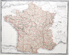
"France"

McPhun's Maps of the World

1863

16 1/2 x 14 1/4 inches

France in Departments
click for details

F-16

"France divided into Departments, etc."

Wilkinson's General Atlas of the World

1805 (1809)

13 1/2 x 10 9/16 inches

France in Departments
click for details

F-17

"France divided into Provinces"

Wilkinson's General Atlas of the World

1805 (1809)

13 1/2 x 10 9/16 inches


click for details

F-18

"France divided into Governments
as it was before the Revolution, 1790"

Wilkinson's General Atlas of the World

1810

13 1/2 x 10 9/16 inches


click for details

F-19

"France"

S.A. Oddy's General Atlas of the World

London, 1811

10 1/4 x 15 1/4 inches


click for details

F-20

"France in Provinces"

John Thomson's A General Atlas...

Edinburgh, 1819

13 1/4 x 10 1/4 inches


click for details

F-21

"France in Departments"

John Thomson's A General Atlas...

Edinburgh, 1819

13 1/4 x 10 1/4 inches


click for details

F-22

"France"

Henry Teesdale's New General Atlas...

London, 1831

15 1/2 x 18 3/4 inches
[2]
 

For individual French Departments and Colonies, see also Vuillemin/Migeon's Atlas Illustré de la France

Vintage and Antique Maps Home