Since Adirondack Retro acquired Darvill's Rare Prints in August of 2022, we have been working tirelessly on our New State-Of-The Art Website. We are excited to announce that it is now up and running and that our massive inventory of Antique Prints and Rare Maps are being transferred over to the new site daily. In addition to the nearly 500,000 prints found on www.DarvillsRarePrints.com, Adirondack Retro offers an eclectic selection of Antique and Vintage Advertisements along with their Limited Edition Giclee Prints. During this transition, customers will still be able to shop and make purchases on www.DarvillsRarePrints.com. Sign up for our Mailing List and receive our Adirondack Retro Newsletter. When you sign up, we will email you a coupon code for you to get 15% OFF your first order at AdirondackRetro.com. |

Below are the available antique maps of Germany from Darvill's Rare Prints.
(While we endeavour to keep this site up-to-date, all items are subject to prior sale.)
RARE AND ANTIQUE MAPS OF GERMANY |
|||
|---|---|---|---|
(click image for more information, and/or to purchase the map ) |
Title / Publisher / Atlas or publication
Place (Date of publication) Size in inches |
||
|
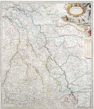
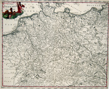
G-39 |
"Ducatus Iuliaci & Bergensis Tabula Geographica, simul Ducatum Cliviae & Meursiae Principatum ... Ducat. Limburgensis" Johann Baptist Homann Nürnberg (circa 1730) 21 x 25 inches
|
||
|
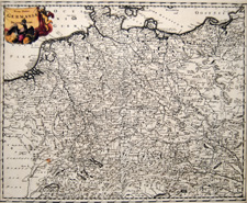
G-38 |
"Cercle de Westphalie" Nicolas Sanson, cartographer to the King of France Paris, 1659 (1664-1666) 17 1/2 x 23 1/2 inches
|
||
|
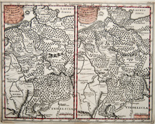
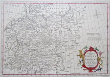
G-1A |
"Nova Totius Germaniae" by Philipp Cluver for Introductionis in universam geographiam... Amsterdam (1697)
13 1/4 x 10 3/4 inches |
||
|
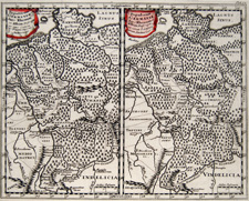
G-1B |
"Nova Totius Germaniae" by Philipp Cluver for Introductionis in universam geographiam... Amsterdam (1697)
13 1/4 x 10 3/4 inches |
||
|
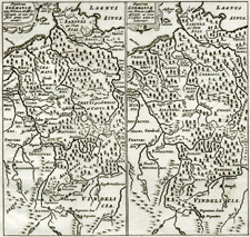
G-1C |
"Nova Totius Germaniae" by Philipp Cluver for Introductionis in universam geographiam... Amsterdam (1697)
13 1/4 x 10 3/4 inches |
||
|
G-1D |
"Populorum Germaniae Inter Rhenum..." by Philipp Cluver for Introductionis in universam geographiam... Amsterdam (1697)
11 1/4 x 8 3/4 inches |
||
|
G-1E |
"Populorum Germaniae Inter Rhenum..." by Philipp Cluver for Introductionis in universam geographiam... Amsterdam (1697)
11 1/4 x 8 3/4 inches |
||
|
G-1F |
"Populorum Germaniae Inter Rhenum..." by Philipp Cluver for Introductionis in universam geographiam... Smaller edition than above (ca. 1701) 5 3/4 x 5 1/4 inches |
||
|
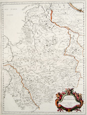
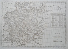
G-39 |
"A New Map of Germany, Divided into Circles, engraved by G. Rollos, unknown publication circa 1764 approx. 14.25 x 8.25 inches |
||
|
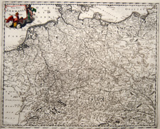
G-38 |
"A New and Correct Map of Germany" Bankes's New System of Geography? circa 1790 approx. 15.25 x 9.5 inches |
||
|
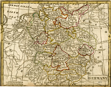
G-2 |
"Germany" BJ Sharman / George Boynton (1800) 11 1/4 x 7 7/16 inches |
||
|
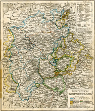
G-3 |
"Westliches Deutschland" Atlas der Erde und des Himmels Weimar (1850) 8 3/4 x 11 inches |
||
|
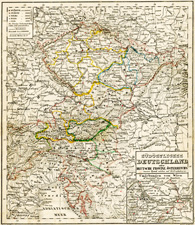
G-4 |
"Suedwestliches Deutschland" Atlas der Erde und des Himmels Weimar (1850) 11 x 8 3/4 inches
|
||
|
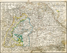
G-5 |
"Suedoestliches Deutschland" Atlas der Erde und des Himmels Weimar (1850) 8 3/4 x 11 inches |
||
|
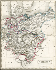
G-6 |
"Germany and Prussia" (1831) 8 1/2 x 10 3/4 inches |
||
|
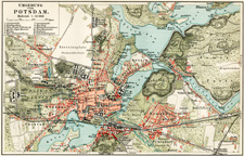
G-7 |
"Umgebung von Potsdam" (1900) 9 1/2 x 6 1/4 inches |
||
|
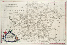
G-8 |
"Circle of Franconia" (1764) 14 x 8 1/2 inches
|
||
|
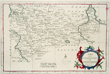
G-9 |
"Southern part of Lower Saxony" (1764) 14 x 8 1/2 inches |
||
|
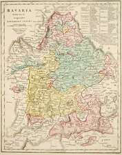
G-10 |
"Bavaria" (1809) 10 9/16 x 13 5/16 inches |
||
|
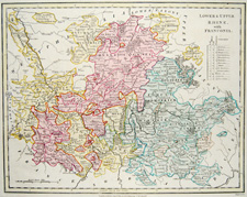
G-11 |
"Lower & Upper Rhine with Franconia" (1809) 13 1/2 x 10 9/16 x inches |
||
|
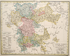
G-12 |
"Lower Saxony" (1809) 13 1/2 x 10 9/16 x inches |
||
|
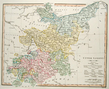
G-13 |
"Upper Saxony" (1809) 13 1/2 x 10 9/16 x inches |
||
|
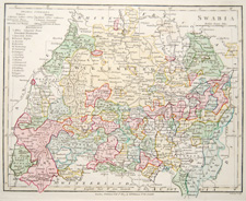
G-14 |
"Swabia" (1809) 13 1/2 x 10 9/16 x inches |
||
|
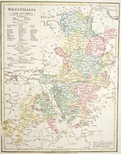
G-15 |
"Westphalia" (1809) 13 1/2 x 10 9/16 x inches |
||

[1] |
 |
Rare and Antique Maps home page