Since Adirondack Retro acquired Darvill's Rare Prints in August of 2022, we have been working tirelessly on our New State-Of-The Art Website. We are excited to announce that it is now up and running and that our massive inventory of Antique Prints and Rare Maps are being transferred over to the new site daily. In addition to the nearly 500,000 prints found on www.DarvillsRarePrints.com, Adirondack Retro offers an eclectic selection of Antique and Vintage Advertisements along with their Limited Edition Giclee Prints. During this transition, customers will still be able to shop and make purchases on www.DarvillsRarePrints.com.
Sign up for our Mailing List and receive our Adirondack Retro Newsletter. When you sign up, we will email you a coupon code for you to get 15% OFF your first order at AdirondackRetro.com.
Genuine Original Antique Maps of North America and the West Indies
THE UNITED STATES OF AMERICA
Original antique maps of North America, including the United States, Canada, Mexico and the West Indies (Caribbean). We do NOT sell reproductions, these are guaranteed genuine antique maps. Sources and dates of publication are cited when known.
PLEASE CLICK ON THE THUMBNAIL IMAGES FOR AN ENLARGED VIEW. THE DIGITAL DARVILL'S WATERMARK IS NOT ON THE ACTUAL PRINT.
Please click on above image for an enlarged view. The digital Darvill's watermark does not appear on the antique map.
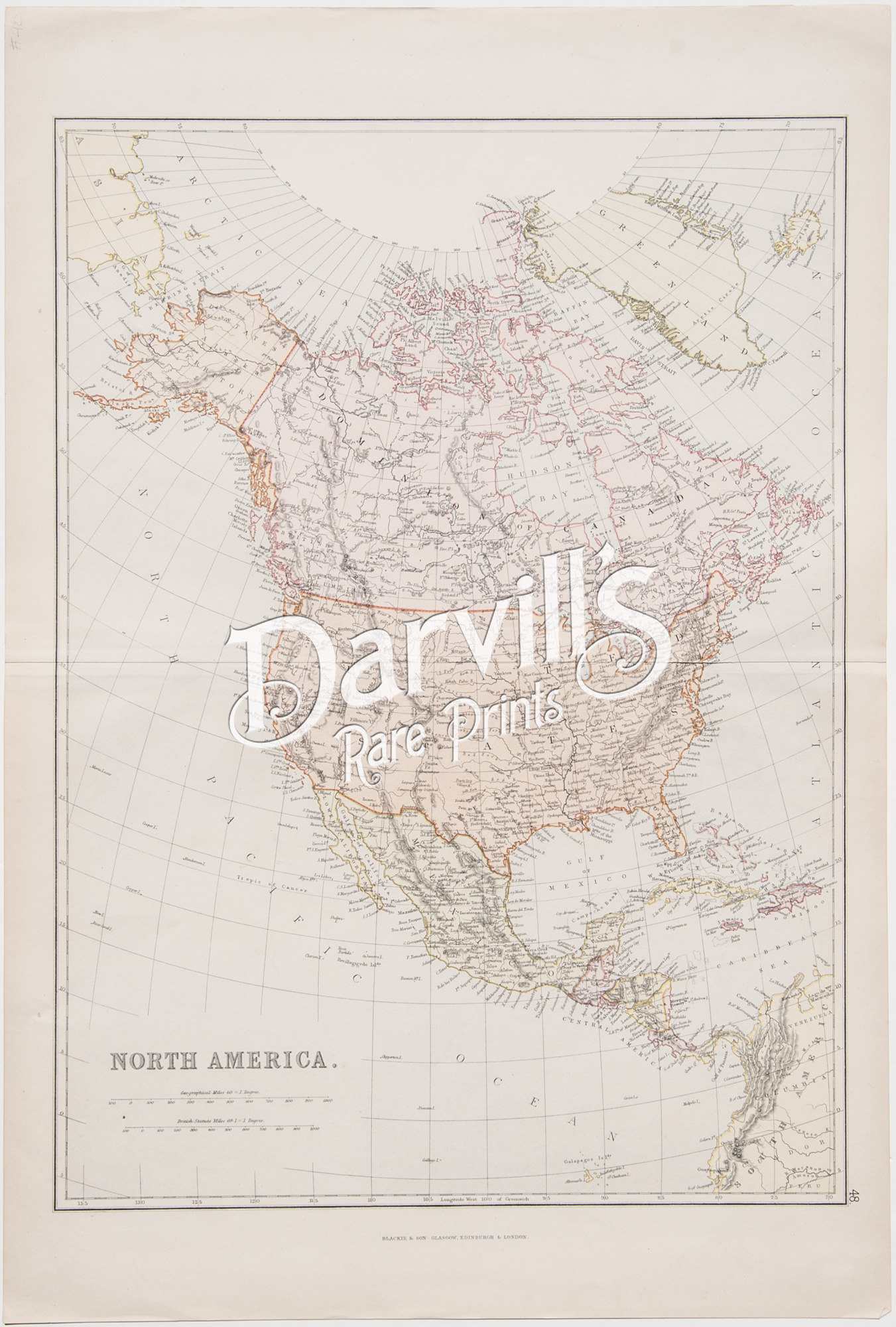
REF: USA-19
North America
The Comprehensive Atlas & Geography of the World, Compiled and Engraved from the most Authentic sources, under the supervision of W.G. Blackie
Published by Blackie & Son, Edinburgh & London
(1882)
Overall sheet size = approx. 15 x 22 inches (38.2 x 56 cm)
Image size (to map's neat line) = approx. 13 1/2 X 18 1/2 inches (34 x 47 cm)
Original color lithograph, over 135 years old • with center fold, as issued
Condition: VERY GOOD to EXCELLENT: mild edge and corner wear and age-appropriate light toning of paper
$95
Please click on above image for an enlarged view. The digital Darvill's watermark does not appear on the antique map.
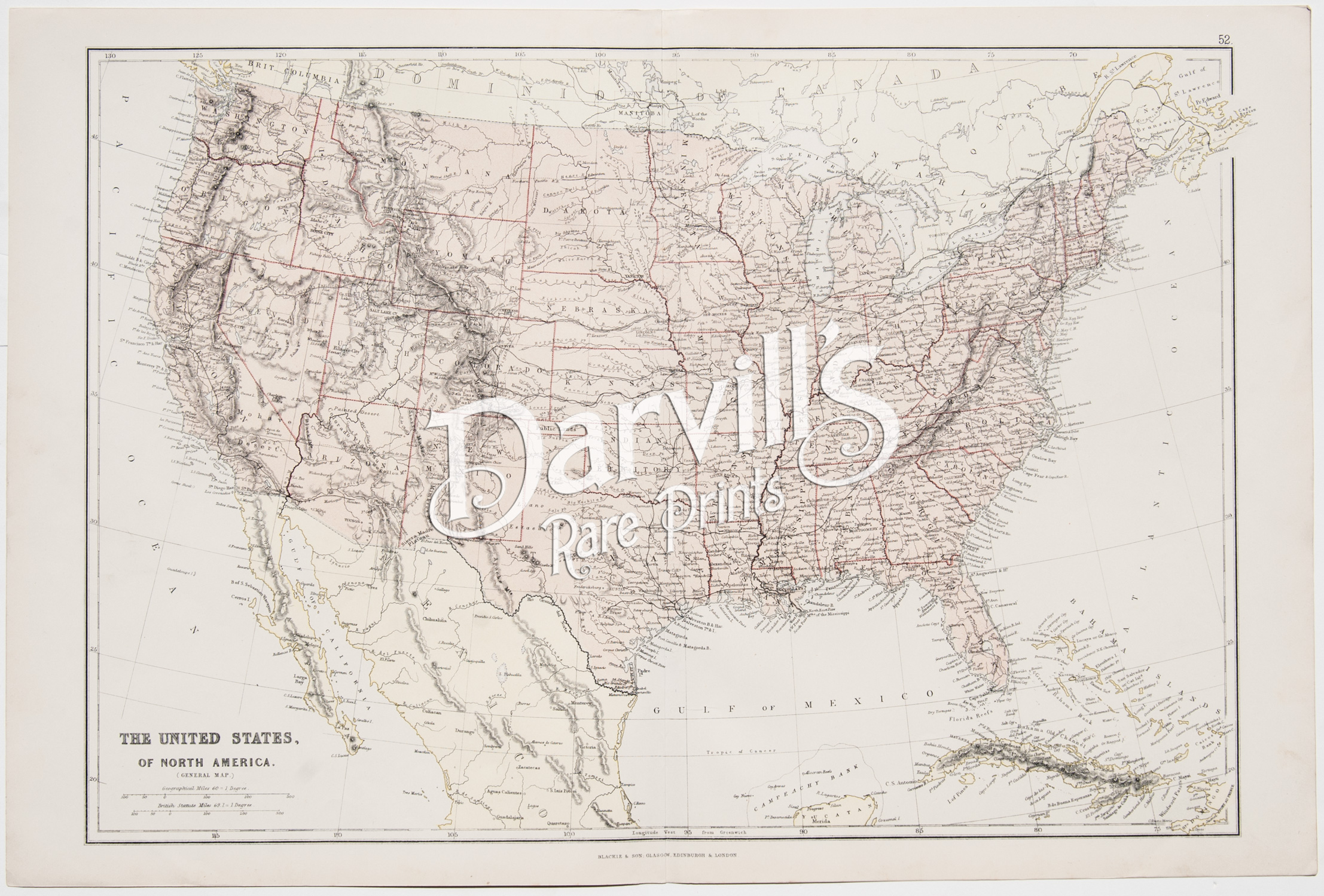
REF: USA-20
The United States, of North America
The Comprehensive Atlas & Geography of the World, Compiled and Engraved from the most Authentic sources, under the supervision of W.G. Blackie
Published by Blackie & Son, Edinburgh & London
(1882)
Overall sheet size = approx. 22 x 15 inches (38.2 x 56 cm)
Image size (to map's neat line) = approx. 19 1/2 X 13 1/2 inches (34 x 47 cm)
Original color lithograph, over 135 years old • with center fold, as issued
Condition: VERY GOOD to EXCELLENT: mild edge and corner wear and age-appropriate light toning of paper
$125
Please click on above image for an enlarged view. The digital Darvill's watermark does not appear on the antique map.
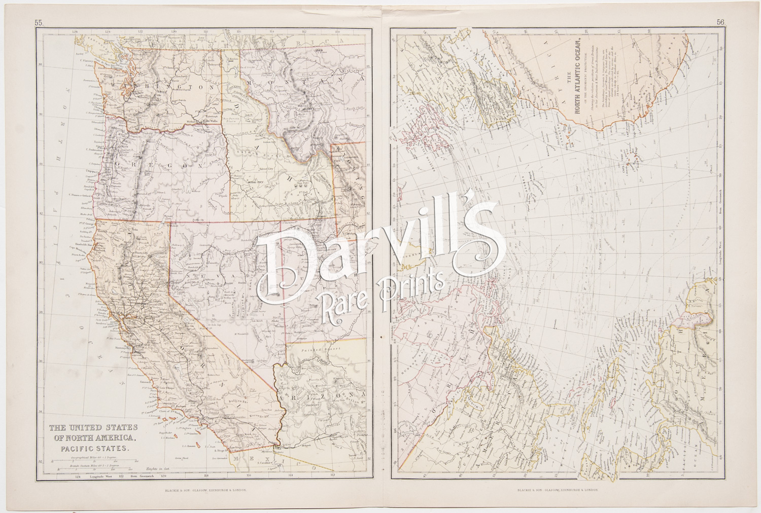
REF: USA-21
The United States of North America, Pacific States
The North Atlantic Ocean
The Comprehensive Atlas & Geography of the World, Compiled and Engraved from the most Authentic sources, under the supervision of W.G. Blackie
Published by Blackie & Son, Edinburgh & London
(1882)
Overall sheet size = approx. 22 x 15 inches (38.2 x 56 cm)
Image size (to map's neat line) = approx. 10 X 13 1/2 inches (25.5 x 47 cm) EACH MAP
Original color lithograph, over 135 years old • with center fold, as issued
Condition: VERY GOOD to EXCELLENT: mild edge and corner wear and age-appropriate light toning of paper
$85
Please click on above image for an enlarged view. The digital Darvill's watermark does not appear on the antique map.
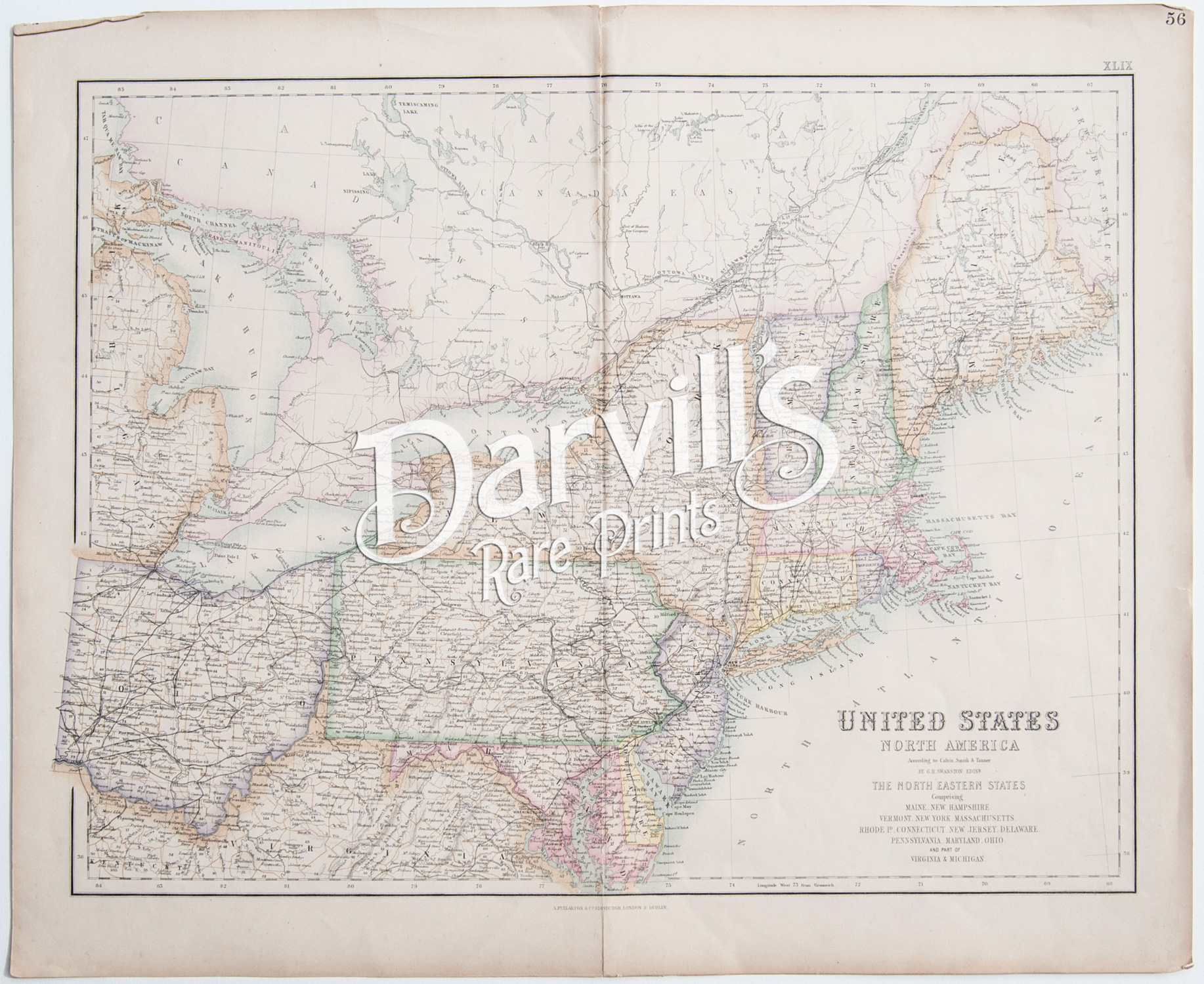
REF: USA-22
The United States
North America According to Calvin, Smith & Tanner
by G.H. Swanson, Edinburgh
The North Eastern States (Maine, New Hampshire, Vermont, New York, Massachusets, Rhode Island, Connecticut, New Jersey, Delaware, Pennsylvania, Maryland, Ohio, and part of Virginia & Michigan)
Fullarton's Royal Illustrated Atlas
Published by A. Fullarton & Co, Edinburgh, London & Dublin
(1854-1862)
Overall sheet size = approx. 22 1/2 x 18 1/2 inches (57 x 47 cm)
Image size (to map's neat line) = approx. 20 1/2 X 15 3/4 inches (52 x 47 cm)
Original color lithograph, over 150 years old • with center fold, as issued
Condition: VERY GOOD to EXCELLENT: mild edge and corner wear and age-appropriate light toning of paper, typical split at upper fold
$125
Please click on above image for an enlarged view. The digital Darvill's watermark does not appear on the antique map.
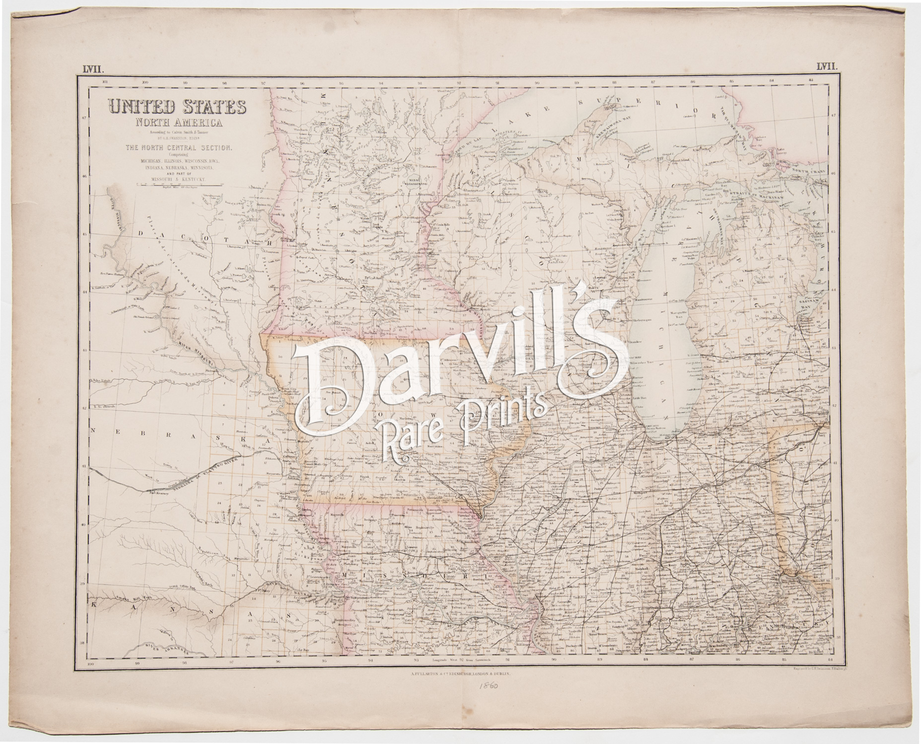
REF: USA-23
The United States
North America According to Calvin, Smith & Tanner
by G.H. Swanson, Edinburgh
The North Central Section (Michigan, Illinois, Wisconsin, Iowa, Indiana, Nebraska, Minnistoa [sic] Minnesota, and part of Missouri & Kentucky)
Fullarton's Royal Illustrated Atlas
Published by A. Fullarton & Co, Edinburgh, London & Dublin
(1854-1862)
Overall sheet size = approx. 22 1/2 x 18 1/2 inches (57 x 47 cm)
Image size (to map's neat line) = approx. 20 1/2 X 15 3/4 inches (52 x 47 cm)
Original color lithograph, over 150 years old • with center fold, as issued
Condition: VERY GOOD to EXCELLENT: edge and corner wear and age-appropriate light toning of paper, short tears at edges, a couple of fox marks in margin
$125
Please click on above image for an enlarged view. The digital Darvill's watermark does not appear on the antique map.
REF: USA-24
The United States
North America According to Calvin, Smith & Tanner
by G.H. Swanson, Edinburgh
The South Eastern States (Mississippi, Georgia, North and South Carolina, and part of Florida, Virginia & Kentucy)
Fullarton's Royal Illustrated Atlas
Published by A. Fullarton & Co, Edinburgh, London & Dublin
(1854-1862)
Overall sheet size = approx. 22 1/2 x 18 1/2 inches (57 x 47 cm)
Image size (to map's neat line) = approx. 20 1/2 X 15 3/4 inches (52 x 47 cm)
Original color lithograph, over 150 years old • with center fold, as issued
Condition: VERY GOOD to EXCELLENT: edge and corner wear and age-appropriate light toning of paper, short tears at edges, a couple of fox marks and a small hole in the title area
$125
Please click on above image for an enlarged view. The digital Darvill's watermark does not appear on the antique map.
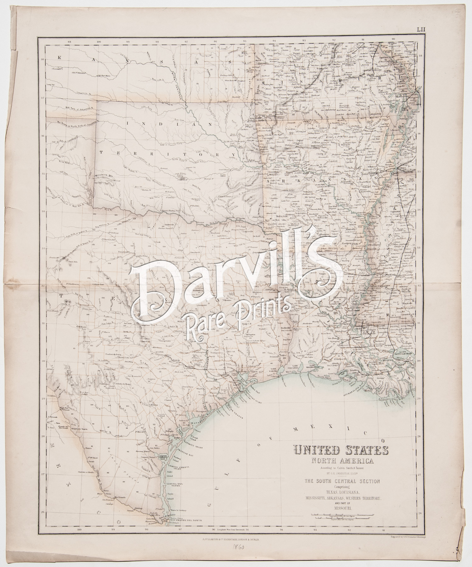
REF: USA-25
The United States
North America According to Calvin, Smith & Tanner
by G.H. Swanson, Edinburgh
The South Central Section (Texas, Louisiana, Mississippi, Arkansas, Western Territory and part of Missouri
Fullarton's Royal Illustrated Atlas
Published by A. Fullarton & Co, Edinburgh, London & Dublin
(1854-1862)
Overall sheet size = approx. 18 1/2 x 22 1/2 inches (47 x 57 cm)
Image size (to map's neat line) = approx. 15 3/4 x 20 1/2 inches (47 x 52 cm)
Original color lithograph, over 150 years old • with center fold, as issued
Condition: VERY GOOD to EXCELLENT: edge and corner wear and age-appropriate light toning of paper, short tears at edges
$125
Please click on above image for an enlarged view. The digital Darvill's watermark does not appear on the antique map.
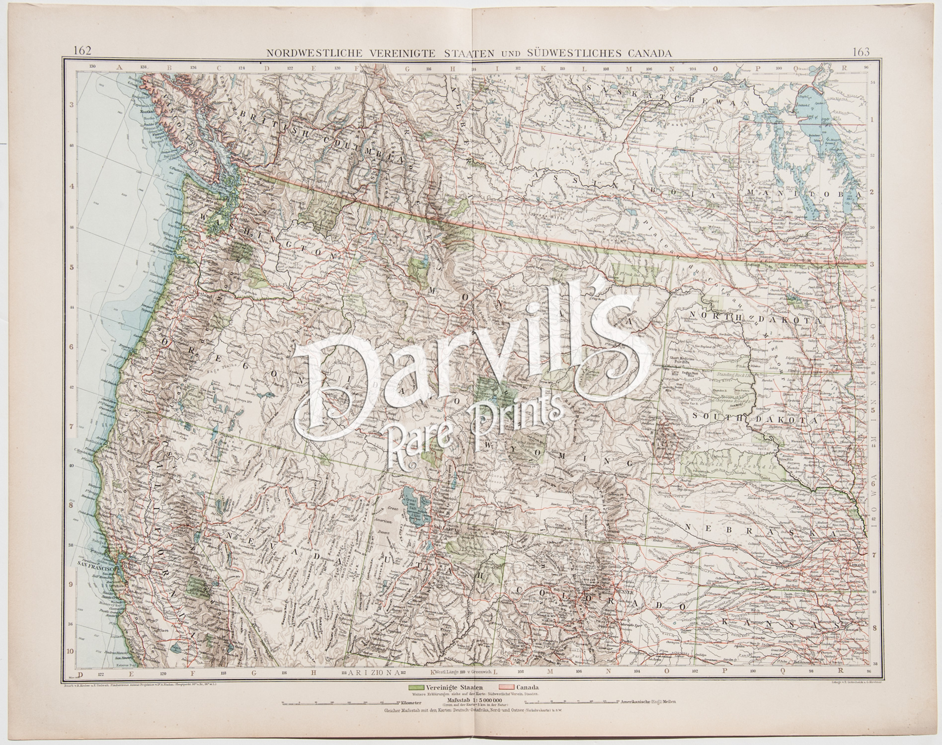
REF: USA-27
Nordwestliche Verienigte Staaten
und
Sudwestliche Canada
(Northwest USA and Southwest Canada)
Steiler's Hand-Atlas
Gotha, Germany, published by Justus Perthus
(1898-1910)
Overall sheet size = approx. 22 x 17 1/2 inches (56 x 44 cm)
Image size (to map's neat line) = approx. 19 1/2 X 15 inches (49 x 38 cm)
Original color lithograph, over 100 years old • with center fold, as issued • text in German
Condition: EXCELLENT: age-appropriate light toning of paper
$30
Please click on above image for an enlarged view. The digital Darvill's watermark does not appear on the antique map.
REF: USA-28
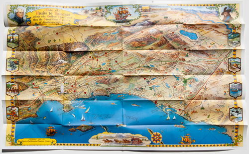
Southern California's Golden Coast and Sunshine Empire
(1963)
Overall sheet size, when fully opened = approx. 35 x 22 inches (84 x 44 cm)
click above thumbnail image for more images
Folded size = approx. 3 3/4 x 8 3/4
Original vintage travel brochure with pictorial map and street map of Los Angeles
Condition: EXCELLENT
$50
Please click on above image for an enlarged view. The digital Darvill's watermark does not appear on the antique map.
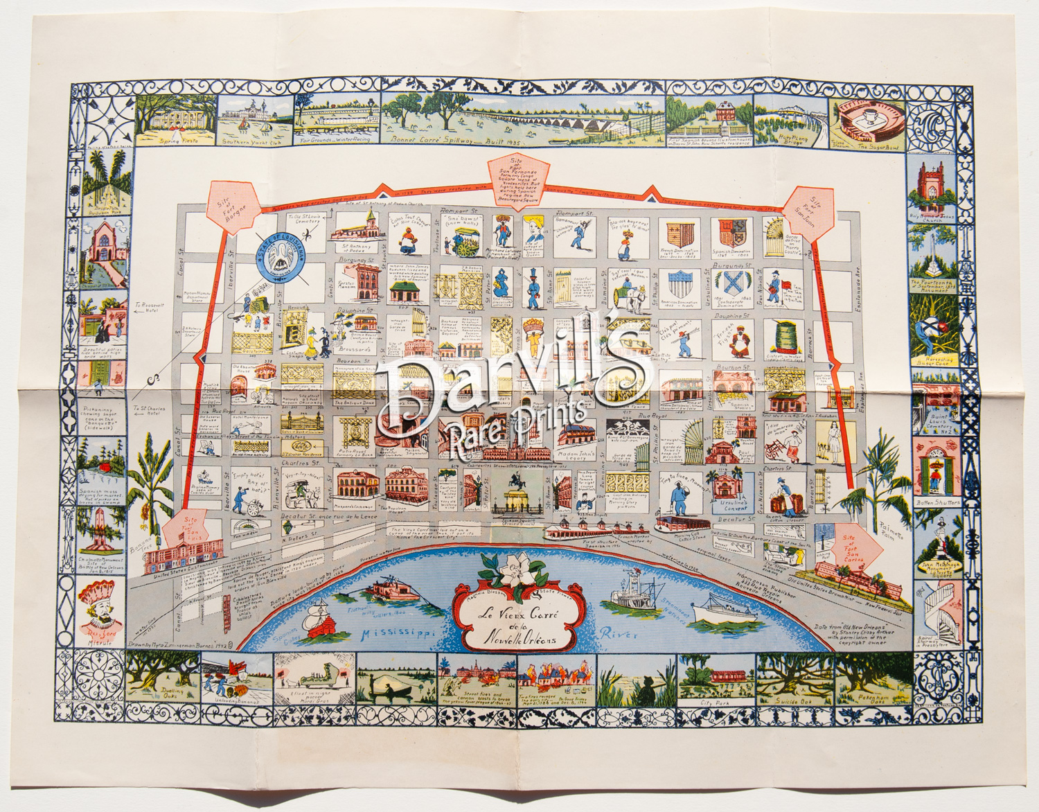
REF: USA-29
La vieux carré de Nouvelle Orléans
(the old quarter of New Orleans)
(1942)
Overall sheet size, when fully opened = approx. 21.5 x 16.5 inches, blank opposite side
Folded size = approx. 5 1/2 x 8 1/2 inches
Condition: VERY GOOD / EXCELLENT – minor discoloration lower margin
(more antique maps of the United States of America)
(antique maps of Canada, British America and parts of the northern U.S.A.)