|
|||||||||||||||||||
Cruchley's Complete Railway and Station Map of England and Wales with Part of Scotland Published by G. F. Cruchley, Map-Seller & Globe Maker
|
|||||||||||||||||||
G.F. CRUCHLEY – CARTOGRAPHER OF THE EARLY RAILWAY AGEGeorge Frederick Cruchley was a cartographer of the middle of the 19th century.
|
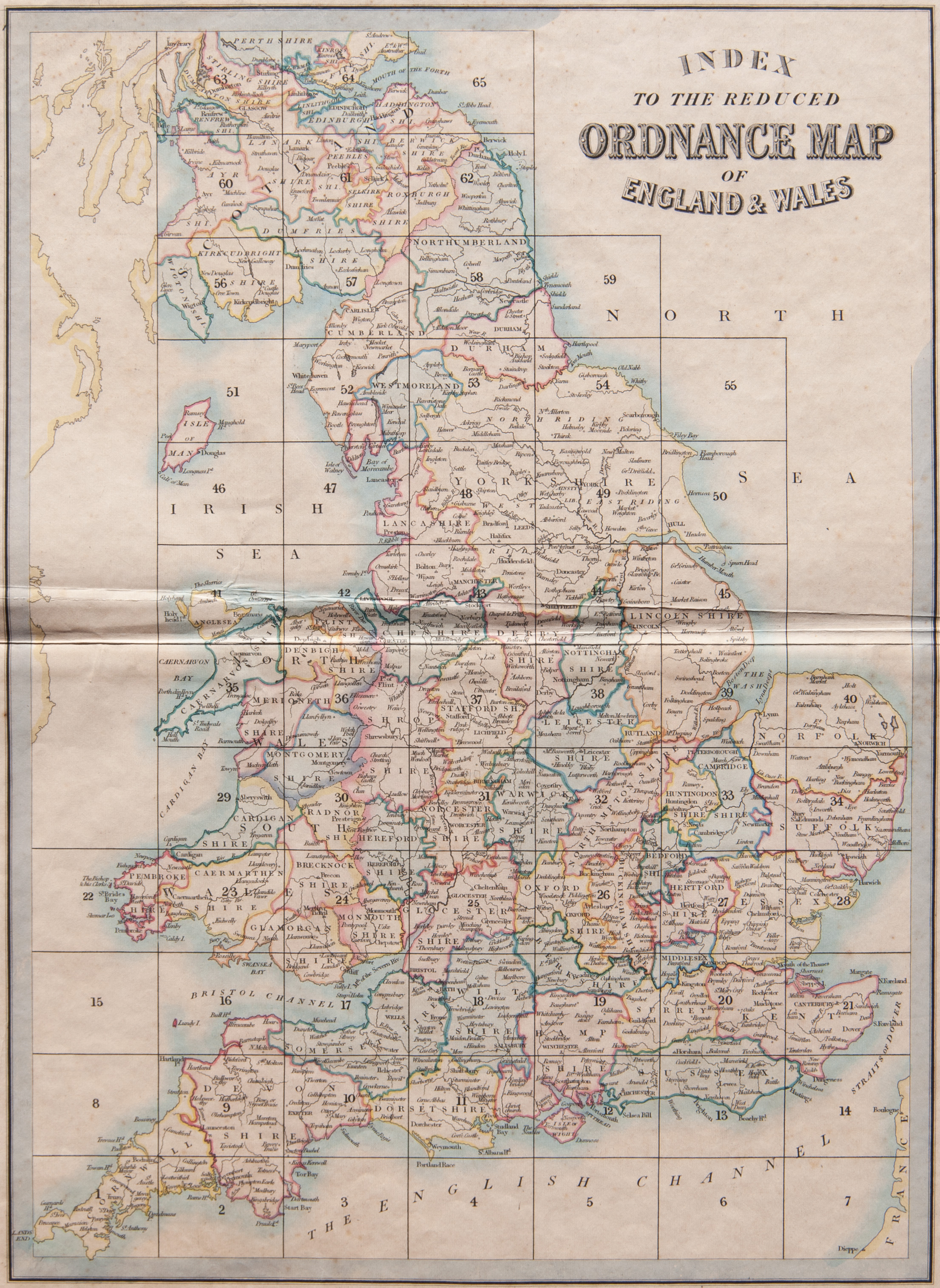
INDEX TO THE MAPS. CLICK ON THE ABOVE IMAGE FOR AN ENLARGED VIEW. THE GRID NUMBERS CORRESPOND TO THE PLATE NUMBERS OF THE MAPS OFFERED FOR SALE BELOW.
 |
| Please click on above image for an enlarged view. The digital Darvill's watermark does not appear on the antique map. |
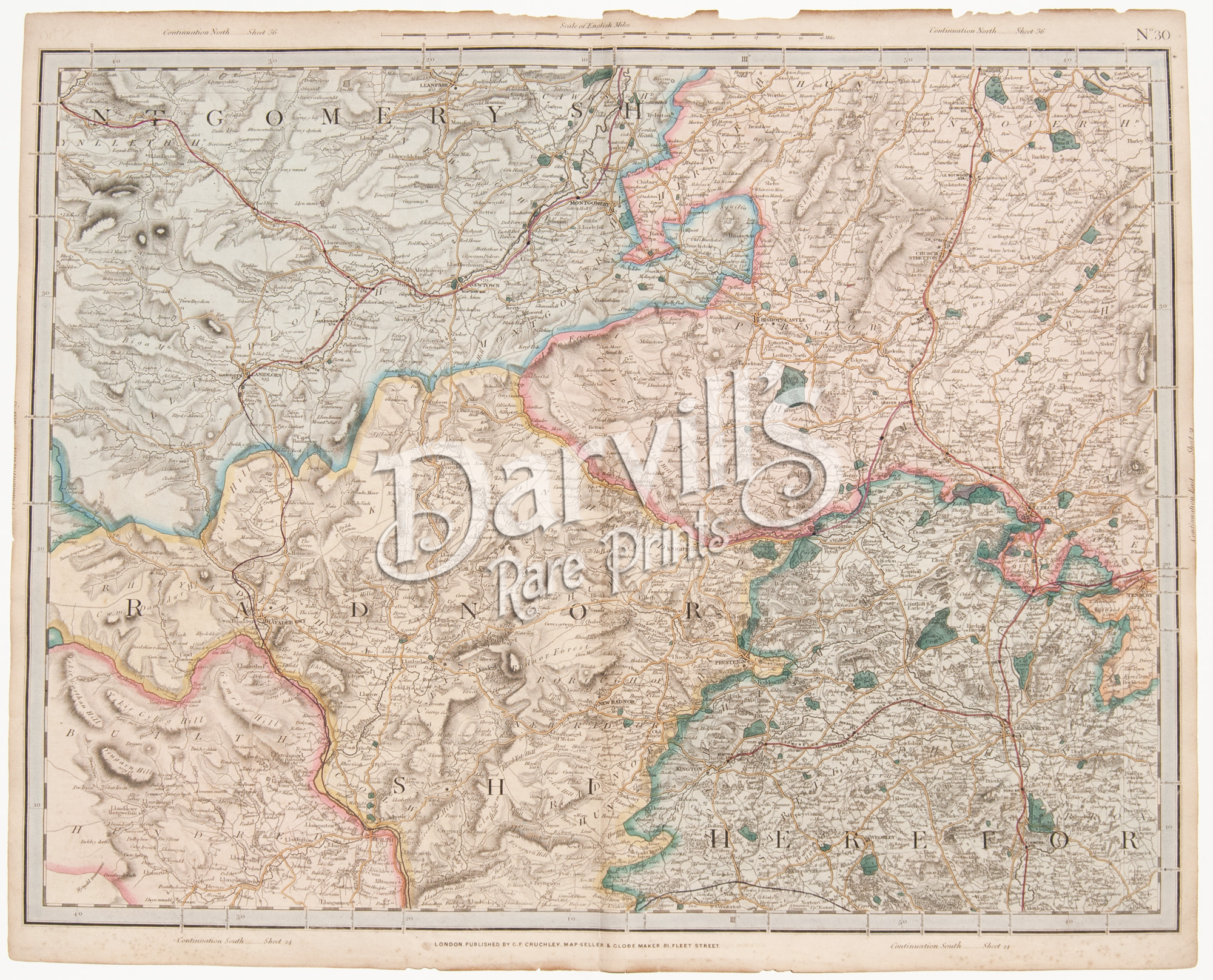
PLATE 30(The index map at the top of this page will help with locations) |
[part of Radnorshire, Herefordshire, Shropshire] |
Cruchley's Complete Railway & Station Map of England and Wales with Part of Scotland Published by G. F. Cruchley, London |
Overall sheet size = approx. 26 x 21 inches (about 66 x 53 cm) Original 155+-year-old maps • hand-colored engraved maps, with center fold, as issued |
NOTE: ALL OF THE MAPS IN THIS SERIES HAVE NUMEROUS EDGE TEARS AND RAGGED TOP MARGINS. THERE IS ALSO AGE-APPROPRIATE TONING OF THE PAPER AND LIGHT FOXING. PLEASE ASSUME THIS TO BE TRUE OF EACH MAP OFFERED HERE. ANY OTHER MAJOR CONDITION ISSUES WILL BE NOTED BELOW.
|

 |
| Please click on above image for an enlarged view. The digital Darvill's watermark does not appear on the antique map. |
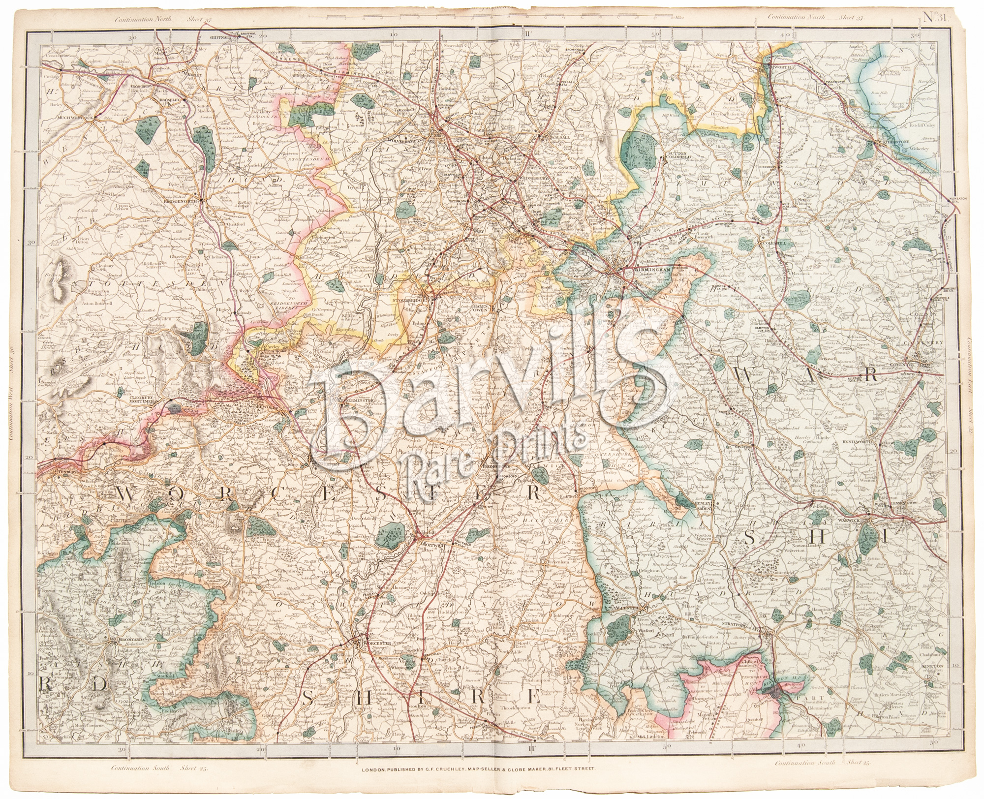
PLATE 31(The index map at the top of this page will help with locations) |
[part of Worcestershire, Warwickshire, Staffordshire] |
Cruchley's Complete Railway & Station Map of England and Wales with Part of Scotland Published by G. F. Cruchley, London |
Overall sheet size = approx. 26 x 21 inches (about 66 x 53 cm) Original 155+-year-old maps • hand-colored engraved maps, with center fold, as issued |
NOTE: ALL OF THE MAPS IN THIS SERIES HAVE NUMEROUS EDGE TEARS AND RAGGED TOP MARGINS. THERE IS ALSO AGE-APPROPRIATE TONING OF THE PAPER AND LIGHT FOXING. PLEASE ASSUME THIS TO BE TRUE OF EACH MAP OFFERED HERE. ANY OTHER MAJOR CONDITION ISSUES WILL BE NOTED BELOW.
|
 |
| Please click on above image for an enlarged view. The digital Darvill's watermark does not appear on the antique map. |
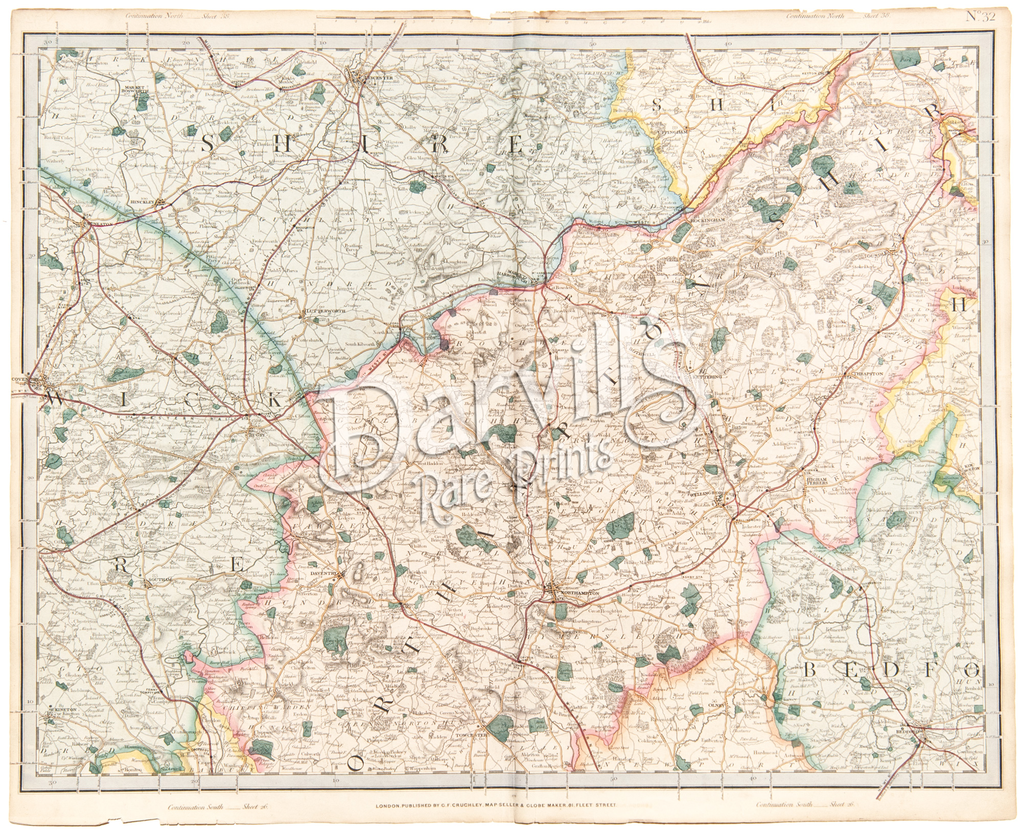
PLATE 32(The index map at the top of this page will help with locations) |
[part of Northamptonshire, Warwickshire, Leicestershire, Bedfordshire] |
Cruchley's Complete Railway & Station Map of England and Wales with Part of Scotland Published by G. F. Cruchley, London |
Overall sheet size = approx. 26 x 21 inches (about 66 x 53 cm) Original 155+-year-old maps • hand-colored engraved maps, with center fold, as issued |
NOTE: ALL OF THE MAPS IN THIS SERIES HAVE NUMEROUS EDGE TEARS AND RAGGED TOP MARGINS. THERE IS ALSO AGE-APPROPRIATE TONING OF THE PAPER AND LIGHT FOXING. PLEASE ASSUME THIS TO BE TRUE OF EACH MAP OFFERED HERE. ANY OTHER MAJOR CONDITION ISSUES WILL BE NOTED BELOW.
|
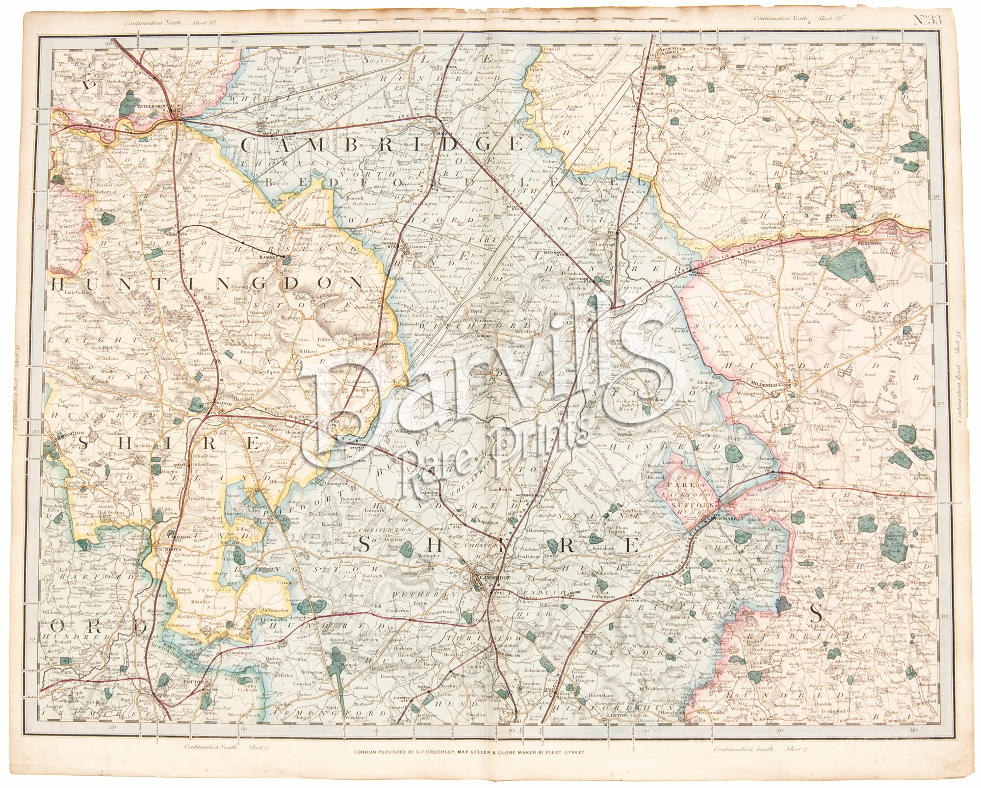 |
| Please click on above image for an enlarged view. The digital Darvill's watermark does not appear on the antique map. |
PLATE 33(The index map at the top of this page will help with locations) |
[part of Cambridgeshire, Huntingdonshire, Suffolk] |
Cruchley's Complete Railway & Station Map of England and Wales with Part of Scotland Published by G. F. Cruchley, London |
Overall sheet size = approx. 26 x 21 inches (about 66 x 53 cm) Original 155+-year-old maps • hand-colored engraved maps, with center fold, as issued |
NOTE: ALL OF THE MAPS IN THIS SERIES HAVE NUMEROUS EDGE TEARS AND RAGGED TOP MARGINS. THERE IS ALSO AGE-APPROPRIATE TONING OF THE PAPER AND LIGHT FOXING. PLEASE ASSUME THIS TO BE TRUE OF EACH MAP OFFERED HERE. ANY OTHER MAJOR CONDITION ISSUES WILL BE NOTED BELOW.
|
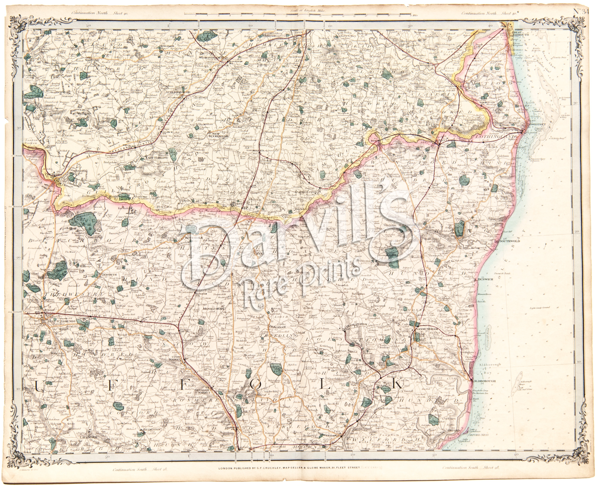 |
| Please click on above image for an enlarged view. The digital Darvill's watermark does not appear on the antique map. |
PLATE 34(The index map at the top of this page will help with locations) |
[part of Suffolk, Norfolk] |
Cruchley's Complete Railway & Station Map of England and Wales with Part of Scotland Published by G. F. Cruchley, London |
Overall sheet size = approx. 26 x 21 inches (about 66 x 53 cm) Original 155+-year-old maps • hand-colored engraved maps, with center fold, as issued |
NOTE: ALL OF THE MAPS IN THIS SERIES HAVE NUMEROUS EDGE TEARS AND RAGGED TOP MARGINS. THERE IS ALSO AGE-APPROPRIATE TONING OF THE PAPER AND LIGHT FOXING. PLEASE ASSUME THIS TO BE TRUE OF EACH MAP OFFERED HERE. ANY OTHER MAJOR CONDITION ISSUES WILL BE NOTED BELOW.
|
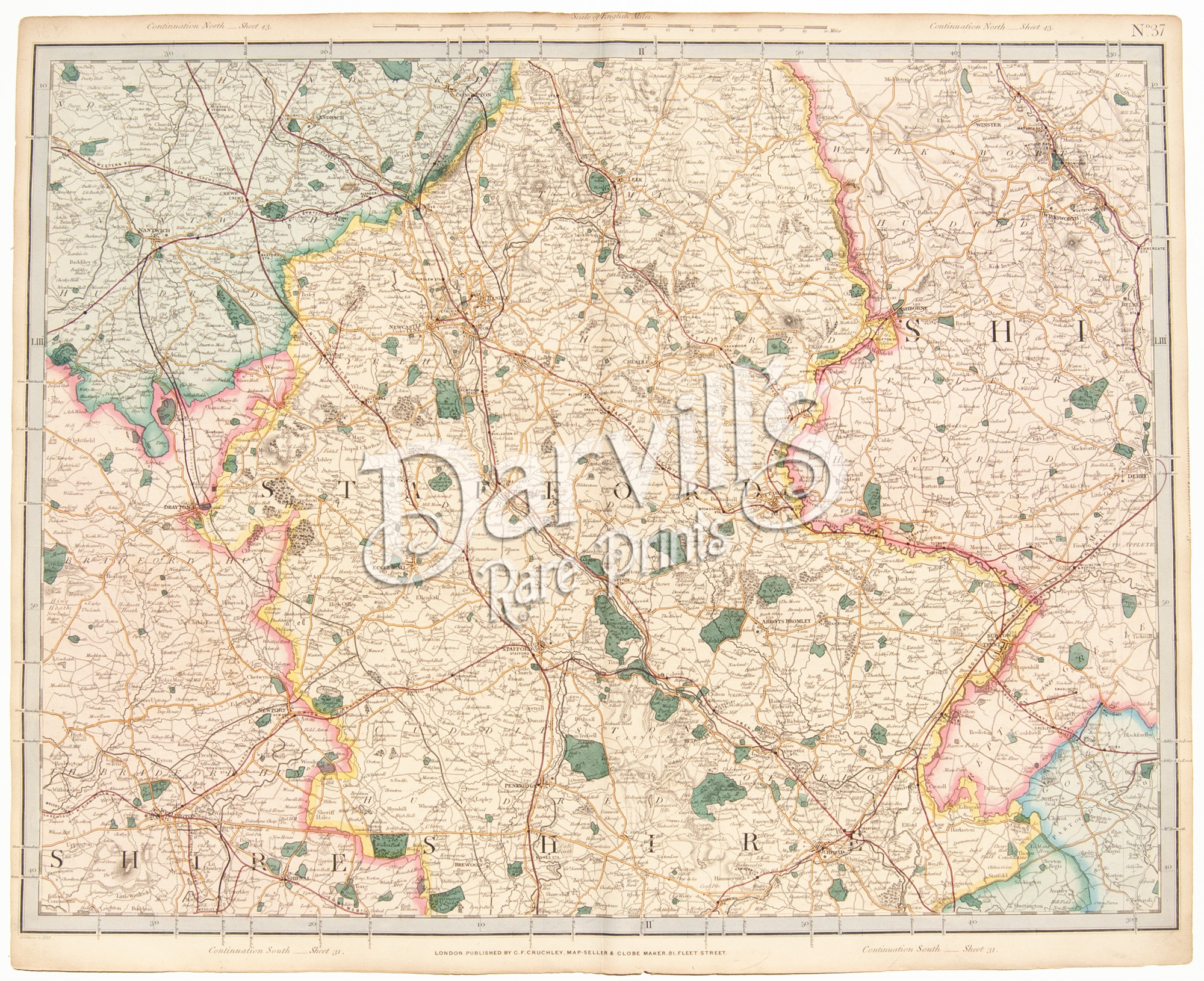 |
| Please click on above image for an enlarged view. The digital Darvill's watermark does not appear on the antique map. |
PLATE 37(The index map at the top of this page will help with locations) |
[part of Staffordshire, Shropshire, Derbyshire] |
Cruchley's Complete Railway & Station Map of England and Wales with Part of Scotland Published by G. F. Cruchley, London |
Overall sheet size = approx. 26 x 21 inches (about 66 x 53 cm) Original 155+-year-old maps • hand-colored engraved maps, with center fold, as issued |
NOTE: ALL OF THE MAPS IN THIS SERIES HAVE NUMEROUS EDGE TEARS AND RAGGED TOP MARGINS. THERE IS ALSO AGE-APPROPRIATE TONING OF THE PAPER AND LIGHT FOXING. PLEASE ASSUME THIS TO BE TRUE OF EACH MAP OFFERED HERE. ANY OTHER MAJOR CONDITION ISSUES WILL BE NOTED BELOW.
|
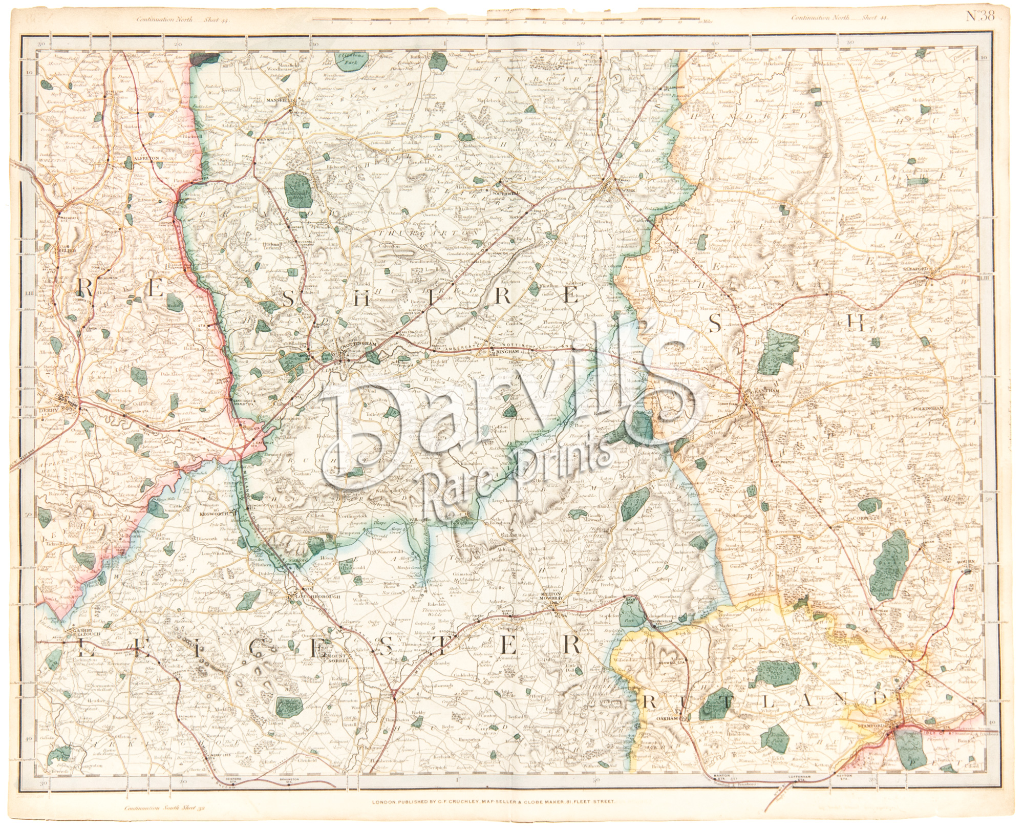 |
| Please click on above image for an enlarged view. The digital Darvill's watermark does not appear on the antique map. |
PLATE 38(The index map at the top of this page will help with locations) |
[part of Leicestershire, Nottinghamshire, Lincolnshire] |
Cruchley's Complete Railway & Station Map of England and Wales with Part of Scotland Published by G. F. Cruchley, London |
Overall sheet size = approx. 26 x 21 inches (about 66 x 53 cm) Original 155+-year-old maps • hand-colored engraved maps, with center fold, as issued |
NOTE: ALL OF THE MAPS IN THIS SERIES HAVE NUMEROUS EDGE TEARS AND RAGGED TOP MARGINS. THERE IS ALSO AGE-APPROPRIATE TONING OF THE PAPER AND LIGHT FOXING. PLEASE ASSUME THIS TO BE TRUE OF EACH MAP OFFERED HERE. ANY OTHER MAJOR CONDITION ISSUES WILL BE NOTED BELOW.
|
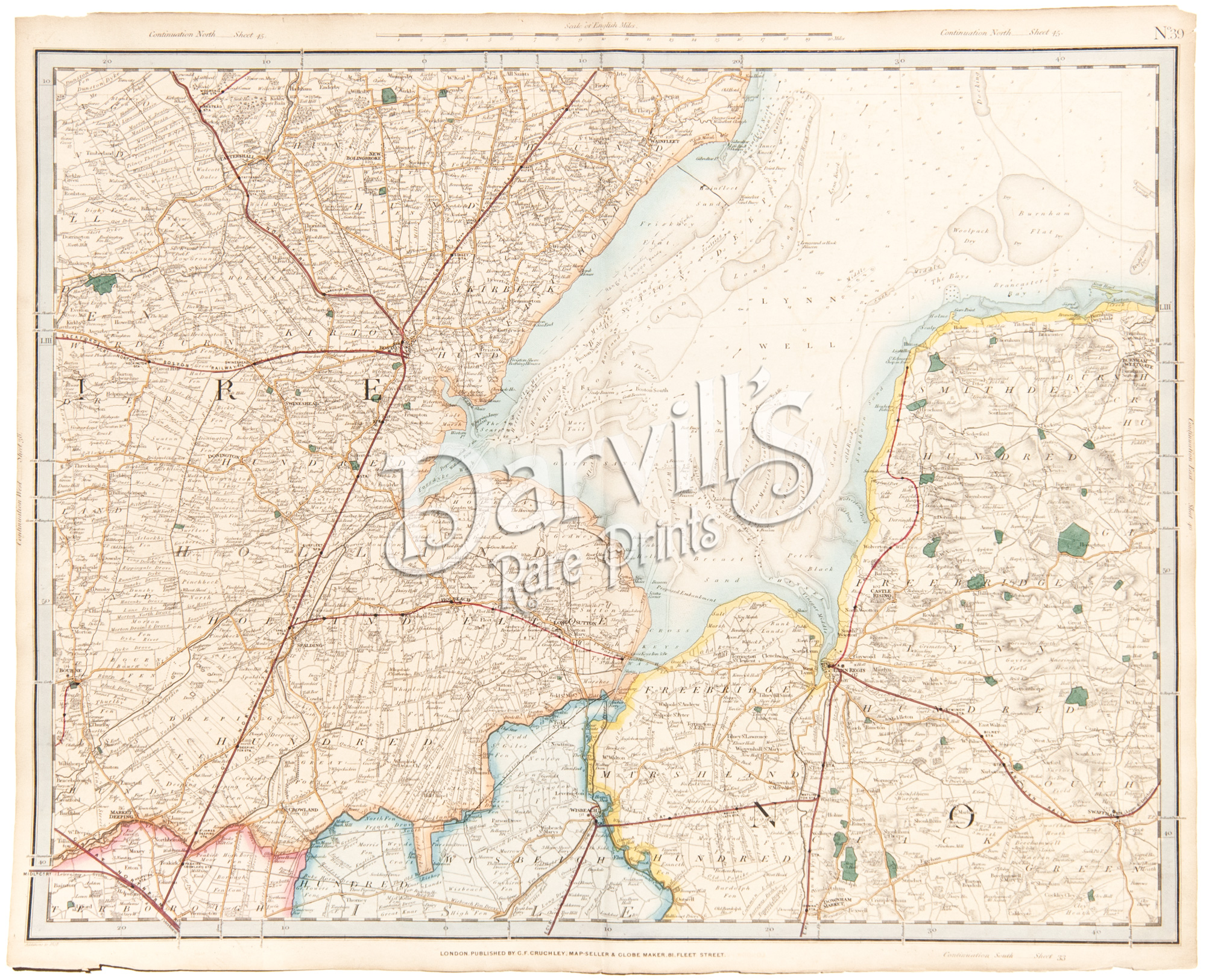 |
| Please click on above image for an enlarged view. The digital Darvill's watermark does not appear on the antique map. |
PLATE 39(The index map at the top of this page will help with locations) |
[part of Lincolnshire, Norfolk] |
Cruchley's Complete Railway & Station Map of England and Wales with Part of Scotland Published by G. F. Cruchley, London |
Overall sheet size = approx. 26 x 21 inches (about 66 x 53 cm) Original 155+-year-old maps • hand-colored engraved maps, with center fold, as issued |
NOTE: ALL OF THE MAPS IN THIS SERIES HAVE NUMEROUS EDGE TEARS AND RAGGED TOP MARGINS. THERE IS ALSO AGE-APPROPRIATE TONING OF THE PAPER AND LIGHT FOXING. PLEASE ASSUME THIS TO BE TRUE OF EACH MAP OFFERED HERE. ANY OTHER MAJOR CONDITION ISSUES WILL BE NOTED BELOW.
|
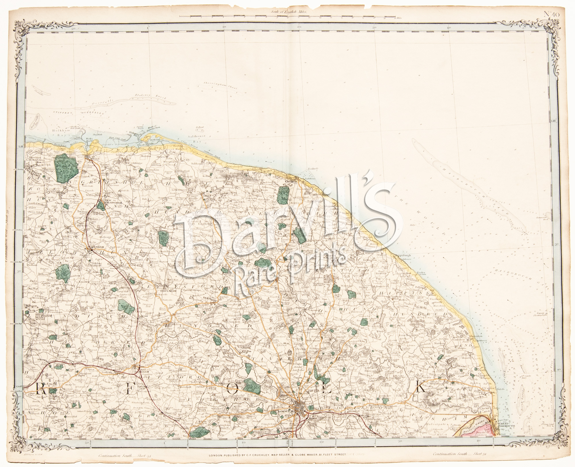 |
| Please click on above image for an enlarged view. The digital Darvill's watermark does not appear on the antique map. |
PLATE 40(The index map at the top of this page will help with locations) |
[part of Norfolk] |
Cruchley's Complete Railway & Station Map of England and Wales with Part of Scotland Published by G. F. Cruchley, London |
Overall sheet size = approx. 26 x 21 inches (about 66 x 53 cm) Original 155+-year-old maps • hand-colored engraved maps, with center fold, as issued |
NOTE: ALL OF THE MAPS IN THIS SERIES HAVE NUMEROUS EDGE TEARS AND RAGGED TOP MARGINS. THERE IS ALSO AGE-APPROPRIATE TONING OF THE PAPER AND LIGHT FOXING. PLEASE ASSUME THIS TO BE TRUE OF EACH MAP OFFERED HERE. ANY OTHER MAJOR CONDITION ISSUES WILL BE NOTED BELOW.
|
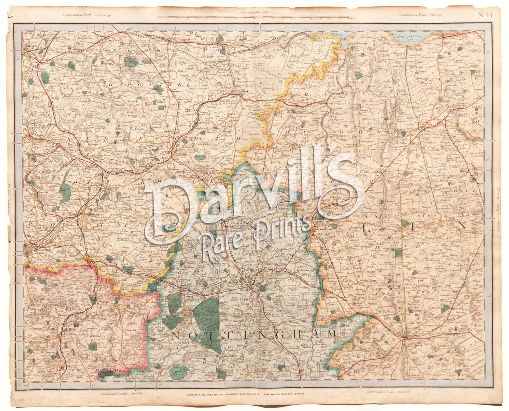 |
| Please click on above image for an enlarged view. The digital Darvill's watermark does not appear on the antique map. |
PLATE 44(The index map at the top of this page will help with locations) |
[part of Leicestershire, Nottinghamshire, Derbyshire, Lincolnshire] |
Cruchley's Complete Railway & Station Map of England and Wales with Part of Scotland Published by G. F. Cruchley, London |
Overall sheet size = approx. 26 x 21 inches (about 66 x 53 cm) Original 155+-year-old maps • hand-colored engraved maps, with center fold, as issued |
NOTE: ALL OF THE MAPS IN THIS SERIES HAVE NUMEROUS EDGE TEARS AND RAGGED TOP MARGINS. THERE IS ALSO AGE-APPROPRIATE TONING OF THE PAPER AND LIGHT FOXING. PLEASE ASSUME THIS TO BE TRUE OF EACH MAP OFFERED HERE. ANY OTHER MAJOR CONDITION ISSUES WILL BE NOTED BELOW.
|
 |
| Please click on above image for an enlarged view. The digital Darvill's watermark does not appear on the antique map. |
PLATE 44(The index map at the top of this page will help with locations) |
[part of Lincolnshire] |
Cruchley's Complete Railway & Station Map of England and Wales with Part of Scotland Published by G. F. Cruchley, London |
Overall sheet size = approx. 26 x 21 inches (about 66 x 53 cm) Original 155+-year-old maps • hand-colored engraved maps, with center fold, as issued |
NOTE: ALL OF THE MAPS IN THIS SERIES HAVE NUMEROUS EDGE TEARS AND RAGGED TOP MARGINS. THERE IS ALSO AGE-APPROPRIATE TONING OF THE PAPER AND LIGHT FOXING. PLEASE ASSUME THIS TO BE TRUE OF EACH MAP OFFERED HERE. ANY OTHER MAJOR CONDITION ISSUES WILL BE NOTED BELOW.
|
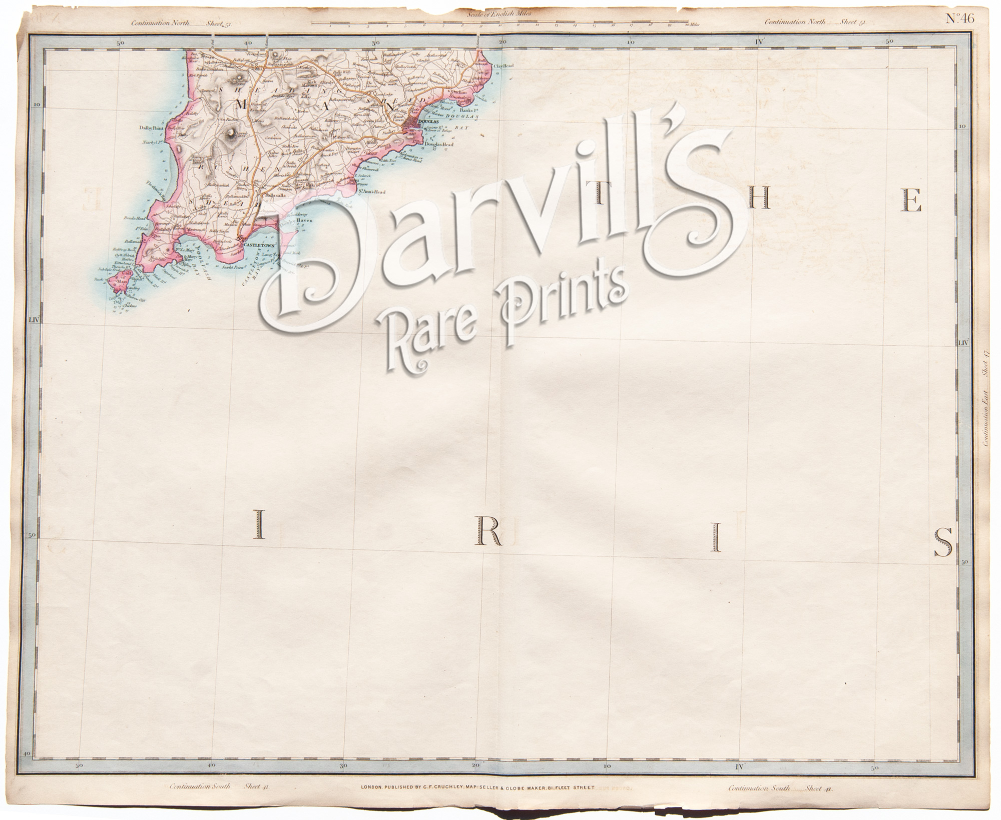 |
| Please click on above image for an enlarged view. The digital Darvill's watermark does not appear on the antique map. |
PLATE 46(The index map at the top of this page will help with locations) |
[south part of the Isle of Man] |
Cruchley's Complete Railway & Station Map of England and Wales with Part of Scotland Published by G. F. Cruchley, London |
Overall sheet size = approx. 26 x 21 inches (about 66 x 53 cm) Original 155+-year-old maps • hand-colored engraved maps, with center fold, as issued |
NOTE: ALL OF THE MAPS IN THIS SERIES HAVE NUMEROUS EDGE TEARS AND RAGGED TOP MARGINS. THERE IS ALSO AGE-APPROPRIATE TONING OF THE PAPER AND LIGHT FOXING. PLEASE ASSUME THIS TO BE TRUE OF EACH MAP OFFERED HERE. ANY OTHER MAJOR CONDITION ISSUES WILL BE NOTED BELOW.
|
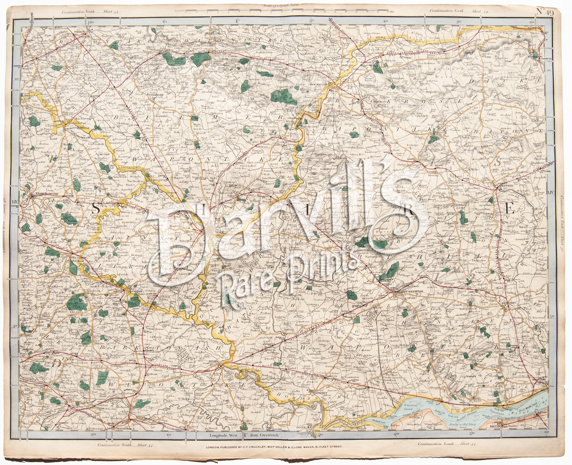 |
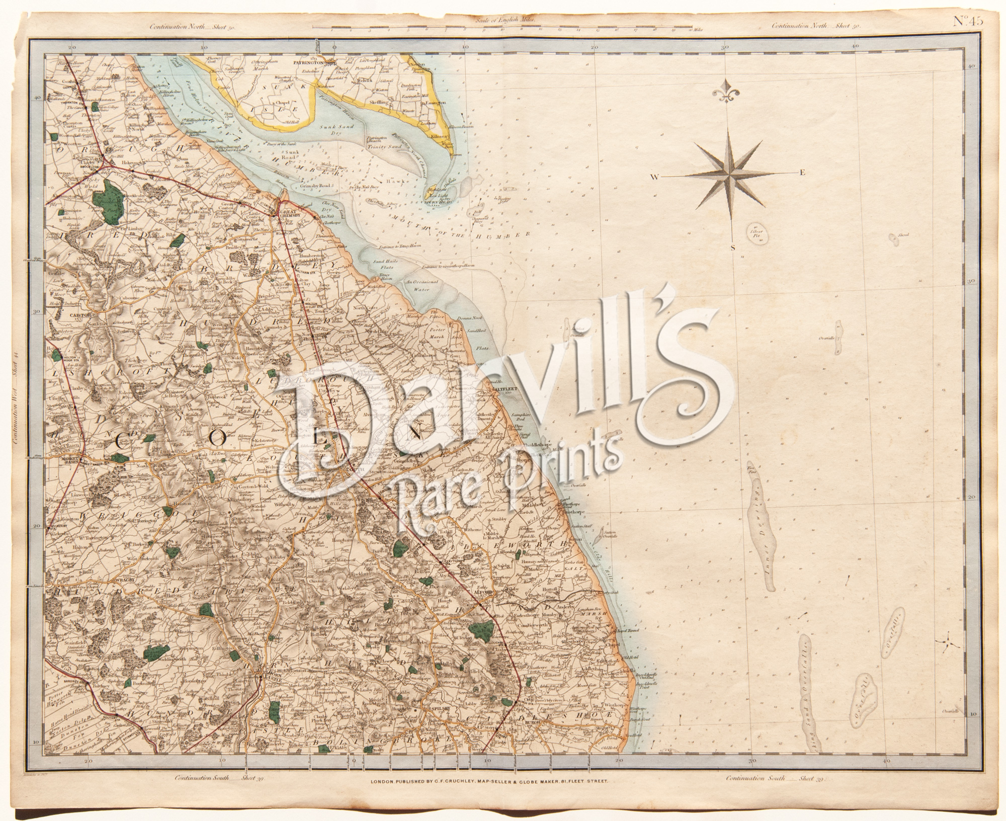
| Please click on above image for an enlarged view. The digital Darvill's watermark does not appear on the antique map. |
PLATE 49(The index map at the top of this page will help with locations) |
[central Yorkshire] |
Cruchley's Complete Railway & Station Map of England and Wales with Part of Scotland Published by G. F. Cruchley, London |
Overall sheet size = approx. 26 x 21 inches (about 66 x 53 cm) Original 155+-year-old maps • hand-colored engraved maps, with center fold, as issued |
NOTE: ALL OF THE MAPS IN THIS SERIES HAVE NUMEROUS EDGE TEARS AND RAGGED TOP MARGINS. THERE IS ALSO AGE-APPROPRIATE TONING OF THE PAPER AND LIGHT FOXING. PLEASE ASSUME THIS TO BE TRUE OF EACH MAP OFFERED HERE. ANY OTHER MAJOR CONDITION ISSUES WILL BE NOTED BELOW.
|
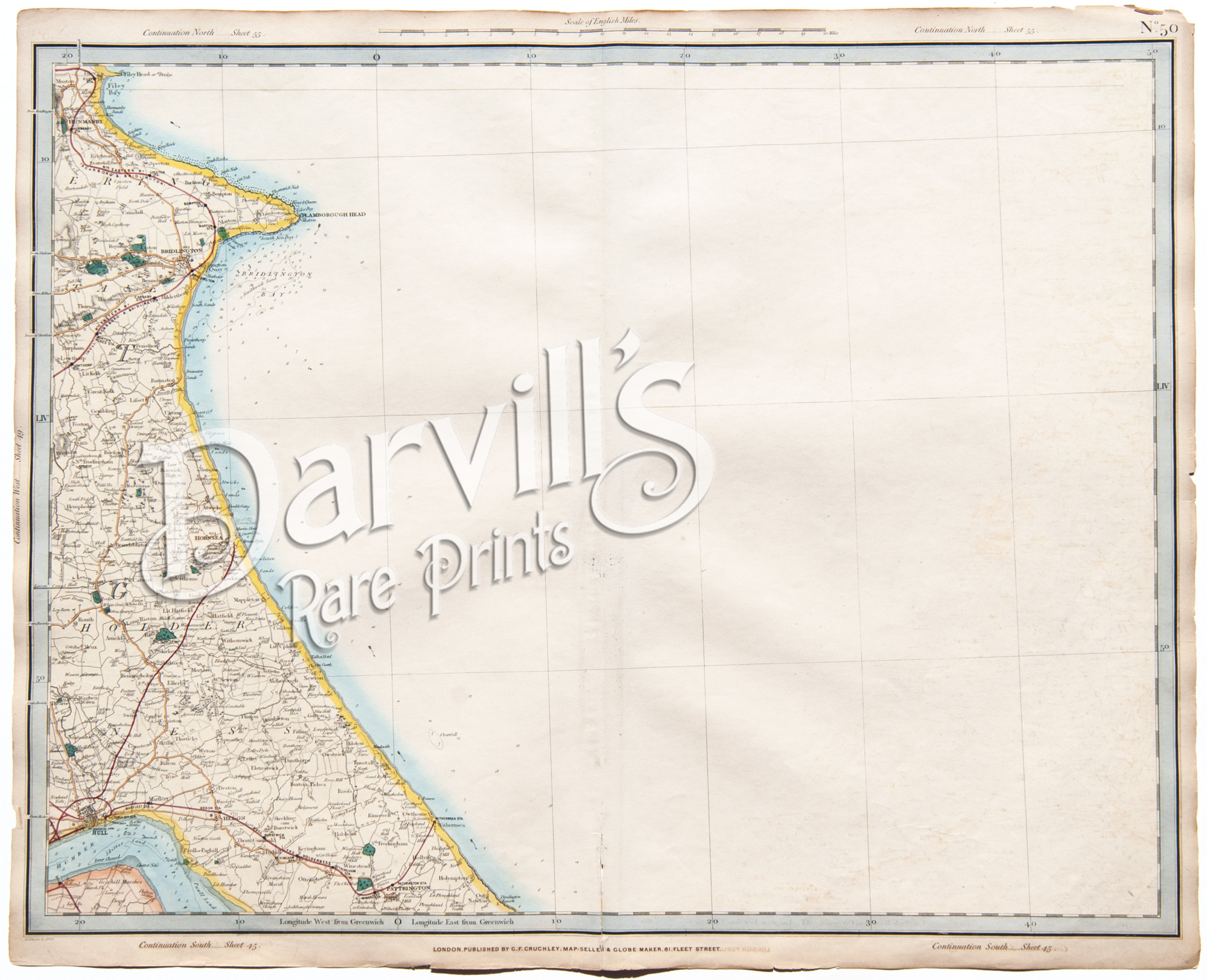 |
| Please click on above image for an enlarged view. The digital Darvill's watermark does not appear on the antique map. |
PLATE 50(The index map at the top of this page will help with locations) |
[east Yorkshire] |
Cruchley's Complete Railway & Station Map of England and Wales with Part of Scotland Published by G. F. Cruchley, London |
Overall sheet size = approx. 26 x 21 inches (about 66 x 53 cm) Original 155+-year-old maps • hand-colored engraved maps, with center fold, as issued |
NOTE: ALL OF THE MAPS IN THIS SERIES HAVE NUMEROUS EDGE TEARS AND RAGGED TOP MARGINS. THERE IS ALSO AGE-APPROPRIATE TONING OF THE PAPER AND LIGHT FOXING. PLEASE ASSUME THIS TO BE TRUE OF EACH MAP OFFERED HERE. ANY OTHER MAJOR CONDITION ISSUES WILL BE NOTED BELOW.
|
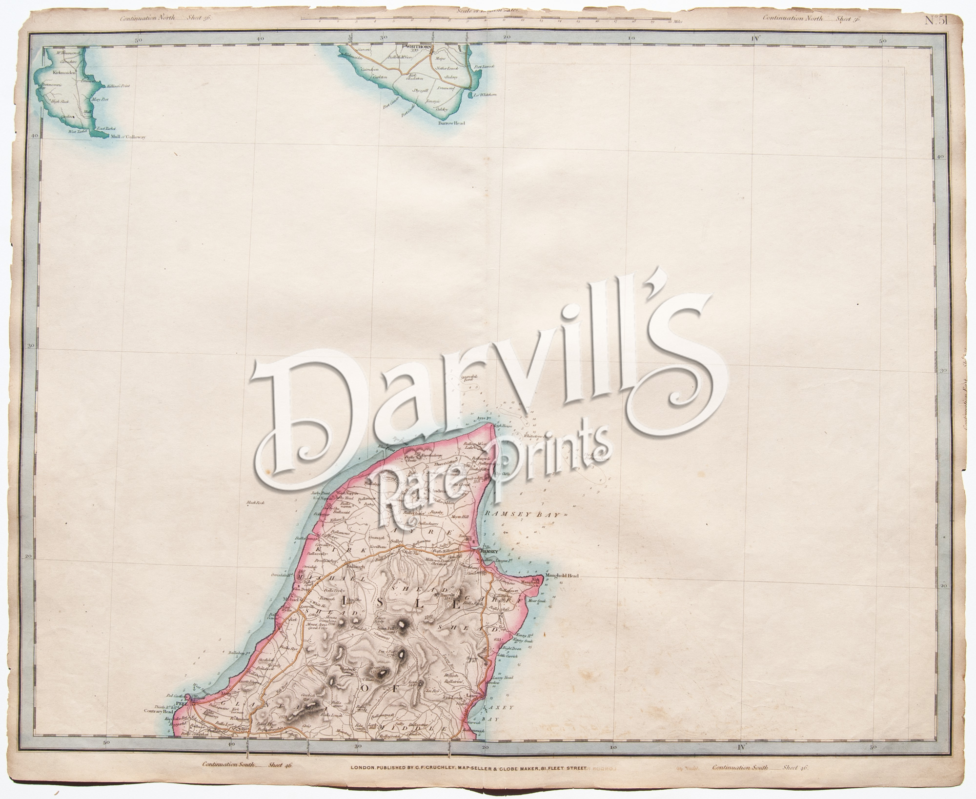 |
| Please click on above image for an enlarged view. The digital Darvill's watermark does not appear on the antique map. |
PLATE 51(The index map at the top of this page will help with locations) |
[north part of the Isle of Man] |
Cruchley's Complete Railway & Station Map of England and Wales with Part of Scotland Published by G. F. Cruchley, London |
Overall sheet size = approx. 26 x 21 inches (about 66 x 53 cm) Original 155+-year-old maps • hand-colored engraved maps, with center fold, as issued |
NOTE: ALL OF THE MAPS IN THIS SERIES HAVE NUMEROUS EDGE TEARS AND RAGGED TOP MARGINS. THERE IS ALSO AGE-APPROPRIATE TONING OF THE PAPER AND LIGHT FOXING. PLEASE ASSUME THIS TO BE TRUE OF EACH MAP OFFERED HERE. ANY OTHER MAJOR CONDITION ISSUES WILL BE NOTED BELOW.
|
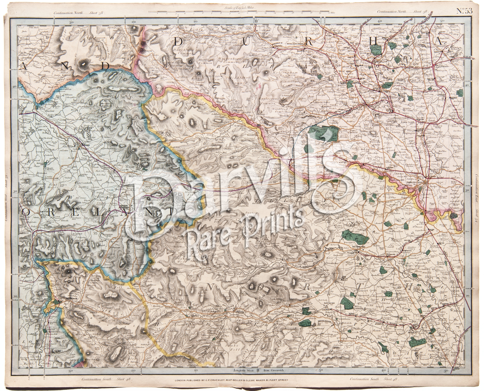 |
| Please click on above image for an enlarged view. The digital Darvill's watermark does not appear on the antique map. |
PLATE 53(The index map at the top of this page will help with locations) |
[part of Westmoreland, Durham, North Riding, Yorkshire] |
Cruchley's Complete Railway & Station Map of England and Wales with Part of Scotland Published by G. F. Cruchley, London |
Overall sheet size = approx. 26 x 21 inches (about 66 x 53 cm) Original 155+-year-old maps • hand-colored engraved maps, with center fold, as issued |
NOTE: ALL OF THE MAPS IN THIS SERIES HAVE NUMEROUS EDGE TEARS AND RAGGED TOP MARGINS. THERE IS ALSO AGE-APPROPRIATE TONING OF THE PAPER AND LIGHT FOXING. PLEASE ASSUME THIS TO BE TRUE OF EACH MAP OFFERED HERE. ANY OTHER MAJOR CONDITION ISSUES WILL BE NOTED BELOW.
|
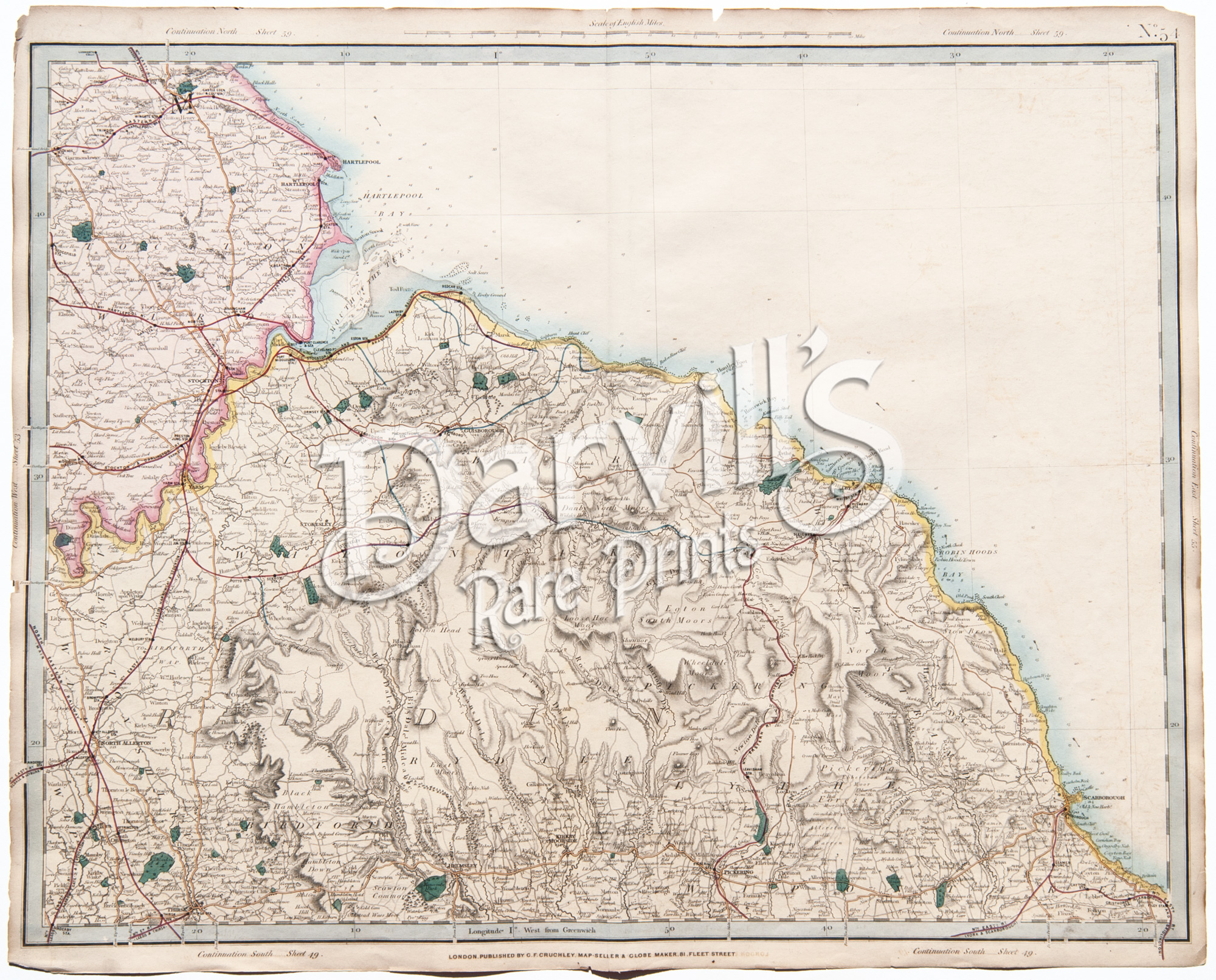 |
| Please click on above image for an enlarged view. The digital Darvill's watermark does not appear on the antique map. |
PLATE 54(The index map at the top of this page will help with locations) |
[part of northeast Yorkshire, southest Durham] |
Cruchley's Complete Railway & Station Map of England and Wales with Part of Scotland Published by G. F. Cruchley, London |
Overall sheet size = approx. 26 x 21 inches (about 66 x 53 cm) Original 155+-year-old maps • hand-colored engraved maps, with center fold, as issued |
NOTE: ALL OF THE MAPS IN THIS SERIES HAVE NUMEROUS EDGE TEARS AND RAGGED TOP MARGINS. THERE IS ALSO AGE-APPROPRIATE TONING OF THE PAPER AND LIGHT FOXING. PLEASE ASSUME THIS TO BE TRUE OF EACH MAP OFFERED HERE. ANY OTHER MAJOR CONDITION ISSUES WILL BE NOTED BELOW.
|
 |
| Please click on above image for an enlarged view. The digital Darvill's watermark does not appear on the antique map. |
PLATE 55(The index map at the top of this page will help with locations) |
[part of east Yorkshire, Filey Bay, Filey Head] |
Cruchley's Complete Railway & Station Map of England and Wales with Part of Scotland Published by G. F. Cruchley, London |
Overall sheet size = approx. 26 x 21 inches (about 66 x 53 cm) Original 155+-year-old maps • hand-colored engraved maps, with center fold, as issued |
NOTE: ALL OF THE MAPS IN THIS SERIES HAVE NUMEROUS EDGE TEARS AND RAGGED TOP MARGINS. THERE IS ALSO AGE-APPROPRIATE TONING OF THE PAPER AND LIGHT FOXING. PLEASE ASSUME THIS TO BE TRUE OF EACH MAP OFFERED HERE. ANY OTHER MAJOR CONDITION ISSUES WILL BE NOTED BELOW.
|
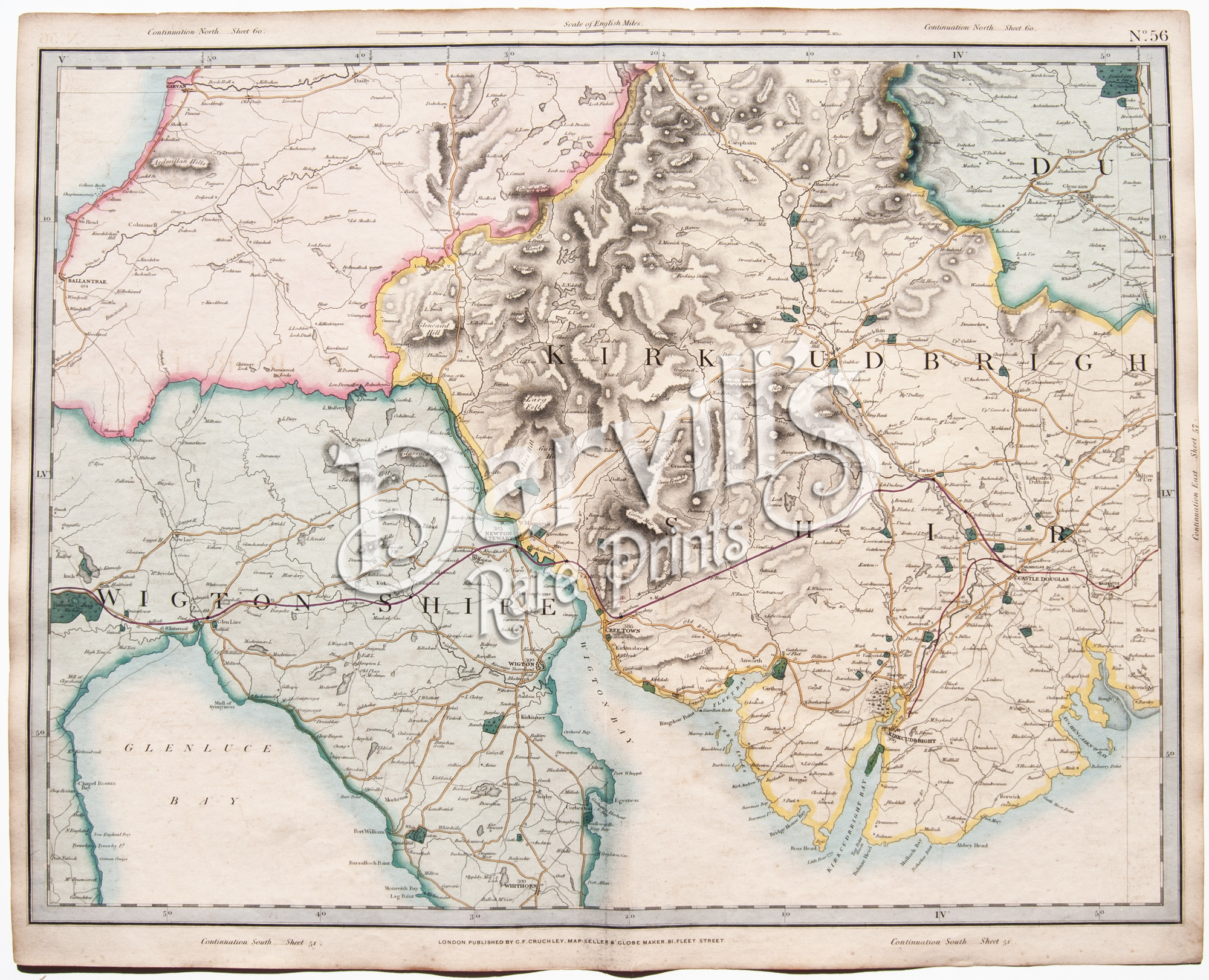 |
| Please click on above image for an enlarged view. The digital Darvill's watermark does not appear on the antique map. |
PLATE 56(The index map at the top of this page will help with locations) |
[part of Wigtonshire, Kirkcudbrightshire, Scotland] |
Cruchley's Complete Railway & Station Map of England and Wales with Part of Scotland Published by G. F. Cruchley, London |
Overall sheet size = approx. 26 x 21 inches (about 66 x 53 cm) Original 155+-year-old maps • hand-colored engraved maps, with center fold, as issued |
NOTE: ALL OF THE MAPS IN THIS SERIES HAVE NUMEROUS EDGE TEARS AND RAGGED TOP MARGINS. THERE IS ALSO AGE-APPROPRIATE TONING OF THE PAPER AND LIGHT FOXING. PLEASE ASSUME THIS TO BE TRUE OF EACH MAP OFFERED HERE. ANY OTHER MAJOR CONDITION ISSUES WILL BE NOTED BELOW.
|
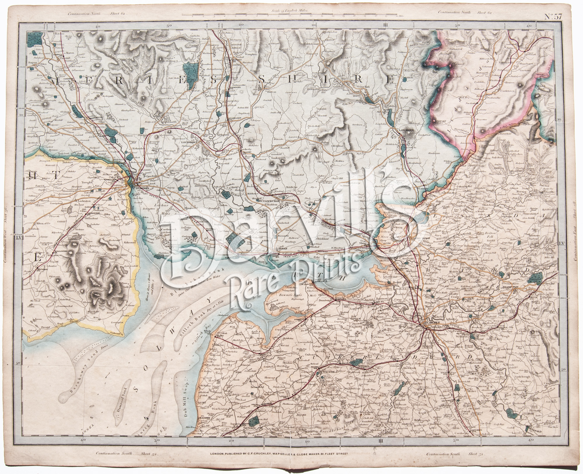 |
| Please click on above image for an enlarged view. The digital Darvill's watermark does not appear on the antique map. |
PLATE 57(The index map at the top of this page will help with locations) |
[part of Dumfries shire, Cumberland, Carlisle, Scotland] |
Cruchley's Complete Railway & Station Map of England and Wales with Part of Scotland Published by G. F. Cruchley, London |
Overall sheet size = approx. 26 x 21 inches (about 66 x 53 cm) Original 155+-year-old maps • hand-colored engraved maps, with center fold, as issued |
NOTE: ALL OF THE MAPS IN THIS SERIES HAVE NUMEROUS EDGE TEARS AND RAGGED TOP MARGINS. THERE IS ALSO AGE-APPROPRIATE TONING OF THE PAPER AND LIGHT FOXING. PLEASE ASSUME THIS TO BE TRUE OF EACH MAP OFFERED HERE. ANY OTHER MAJOR CONDITION ISSUES WILL BE NOTED BELOW.
|
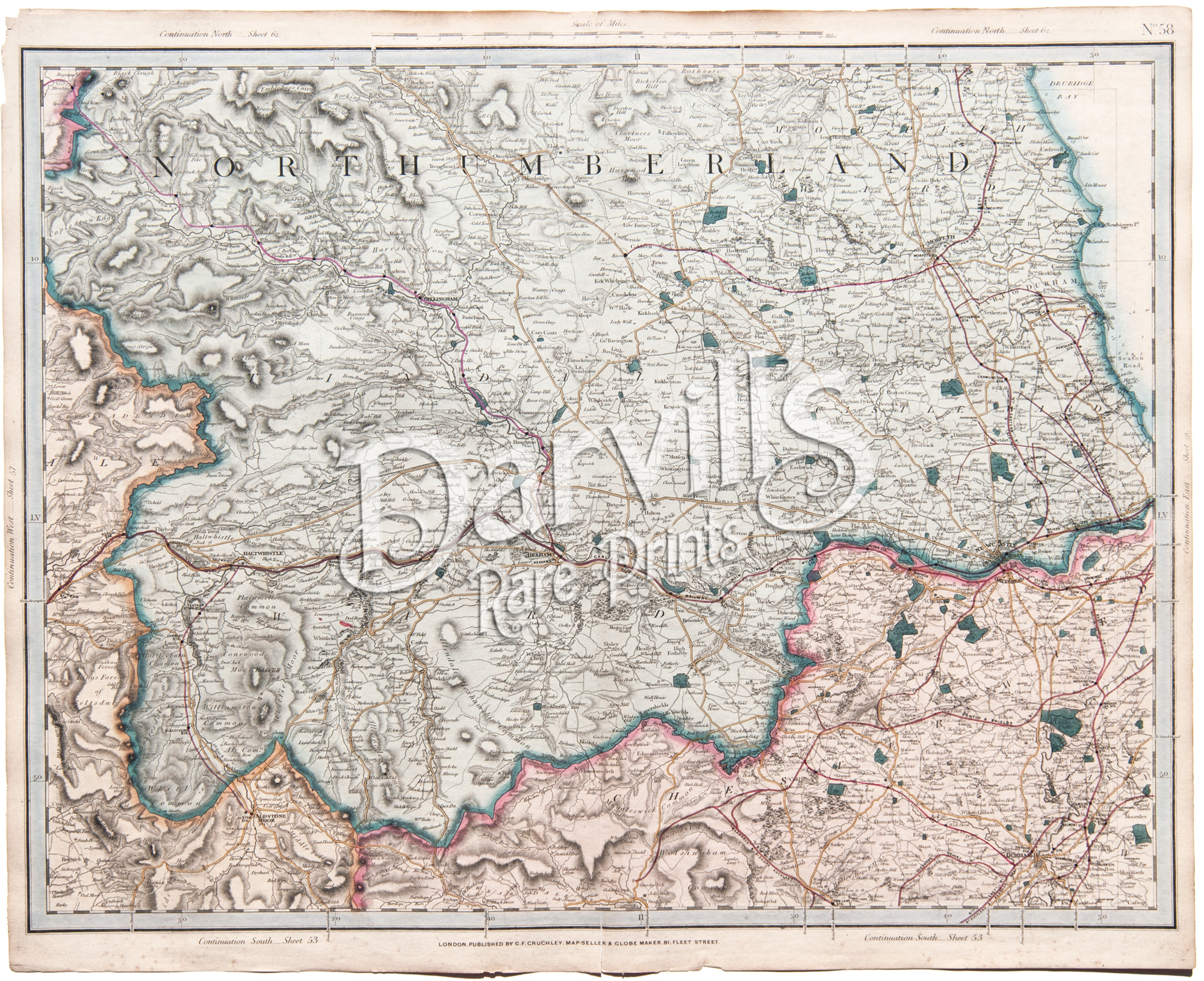 |
| Please click on above image for an enlarged view. The digital Darvill's watermark does not appear on the antique map. |
PLATE 58(The index map at the top of this page will help with locations) |
[part of Northumberland, Cumberland, Durham, England] |
Cruchley's Complete Railway & Station Map of England and Wales with Part of Scotland Published by G. F. Cruchley, London |
Overall sheet size = approx. 26 x 21 inches (about 66 x 53 cm) Original 155+-year-old maps • hand-colored engraved maps, with center fold, as issued |
NOTE: ALL OF THE MAPS IN THIS SERIES HAVE NUMEROUS EDGE TEARS AND RAGGED TOP MARGINS. THERE IS ALSO AGE-APPROPRIATE TONING OF THE PAPER AND LIGHT FOXING. PLEASE ASSUME THIS TO BE TRUE OF EACH MAP OFFERED HERE. ANY OTHER MAJOR CONDITION ISSUES WILL BE NOTED BELOW.
|
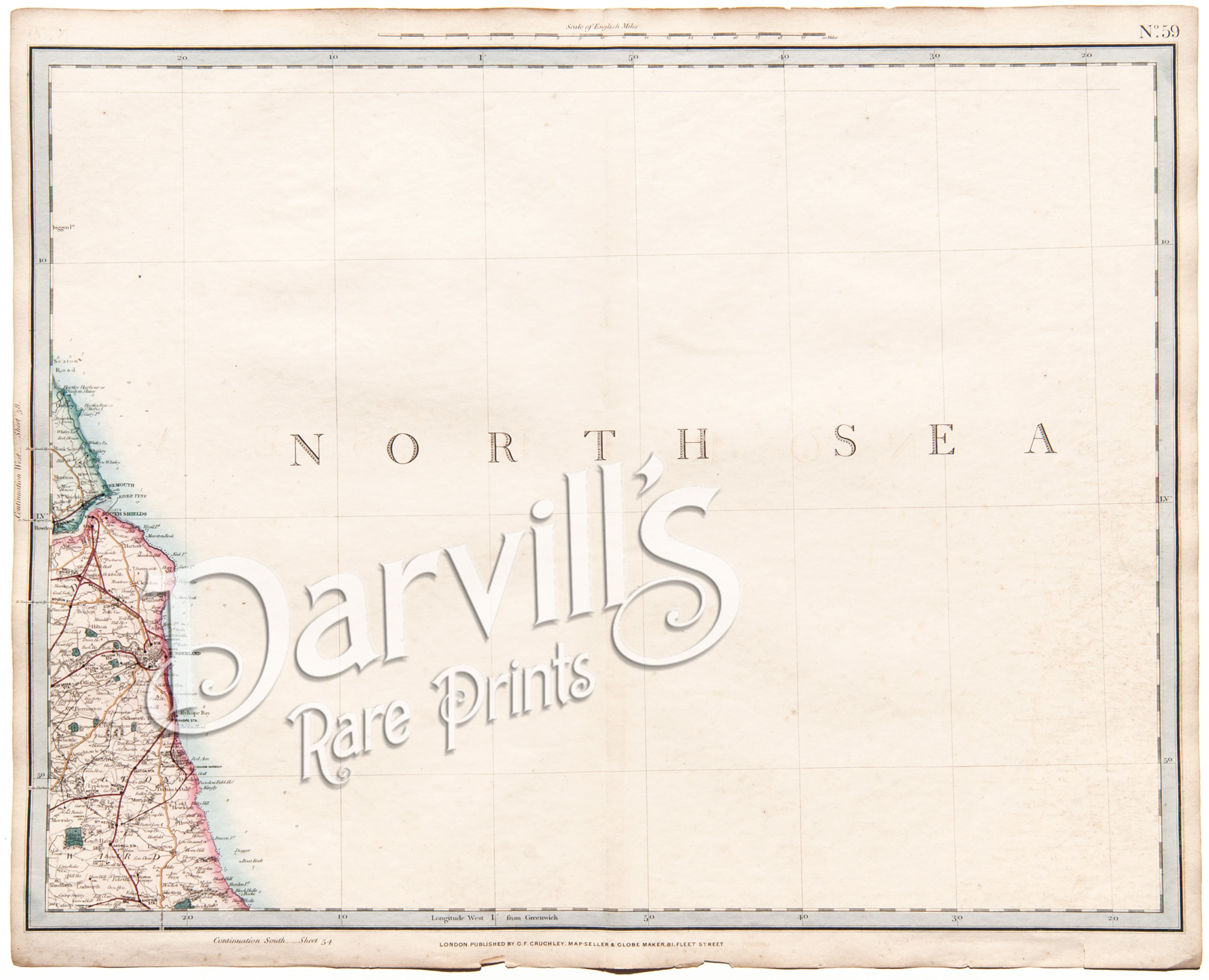 |
| Please click on above image for an enlarged view. The digital Darvill's watermark does not appear on the antique map. |
PLATE 59(The index map at the top of this page will help with locations) |
[part of east coast of Durham, England] |
Cruchley's Complete Railway & Station Map of England and Wales with Part of Scotland Published by G. F. Cruchley, London |
Overall sheet size = approx. 26 x 21 inches (about 66 x 53 cm) Original 155+-year-old maps • hand-colored engraved maps, with center fold, as issued |
NOTE: ALL OF THE MAPS IN THIS SERIES HAVE NUMEROUS EDGE TEARS AND RAGGED TOP MARGINS. THERE IS ALSO AGE-APPROPRIATE TONING OF THE PAPER AND LIGHT FOXING. PLEASE ASSUME THIS TO BE TRUE OF EACH MAP OFFERED HERE. ANY OTHER MAJOR CONDITION ISSUES WILL BE NOTED BELOW.
|
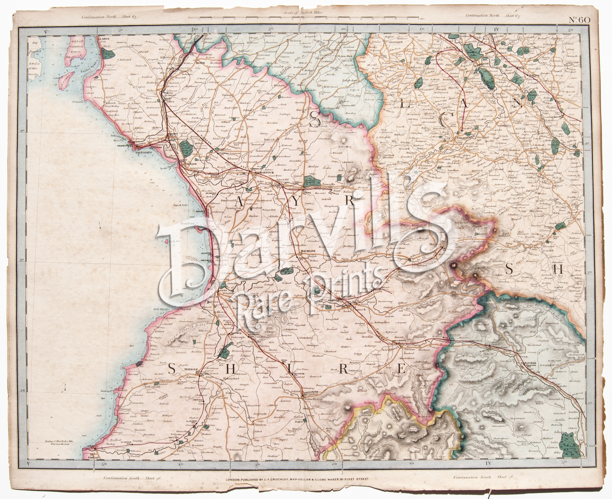 |
| Please click on above image for an enlarged view. The digital Darvill's watermark does not appear on the antique map. |
PLATE 60(The index map at the top of this page will help with locations) |
[part of Ayrshire, Dumfries, Lanarkshire, Scotland] |
Cruchley's Complete Railway & Station Map of England and Wales with Part of Scotland Published by G. F. Cruchley, London |
Overall sheet size = approx. 26 x 21 inches (about 66 x 53 cm) Original 155+-year-old maps • hand-colored engraved maps, with center fold, as issued |
NOTE: ALL OF THE MAPS IN THIS SERIES HAVE NUMEROUS EDGE TEARS AND RAGGED TOP MARGINS. THERE IS ALSO AGE-APPROPRIATE TONING OF THE PAPER AND LIGHT FOXING. PLEASE ASSUME THIS TO BE TRUE OF EACH MAP OFFERED HERE. ANY OTHER MAJOR CONDITION ISSUES WILL BE NOTED BELOW.
|
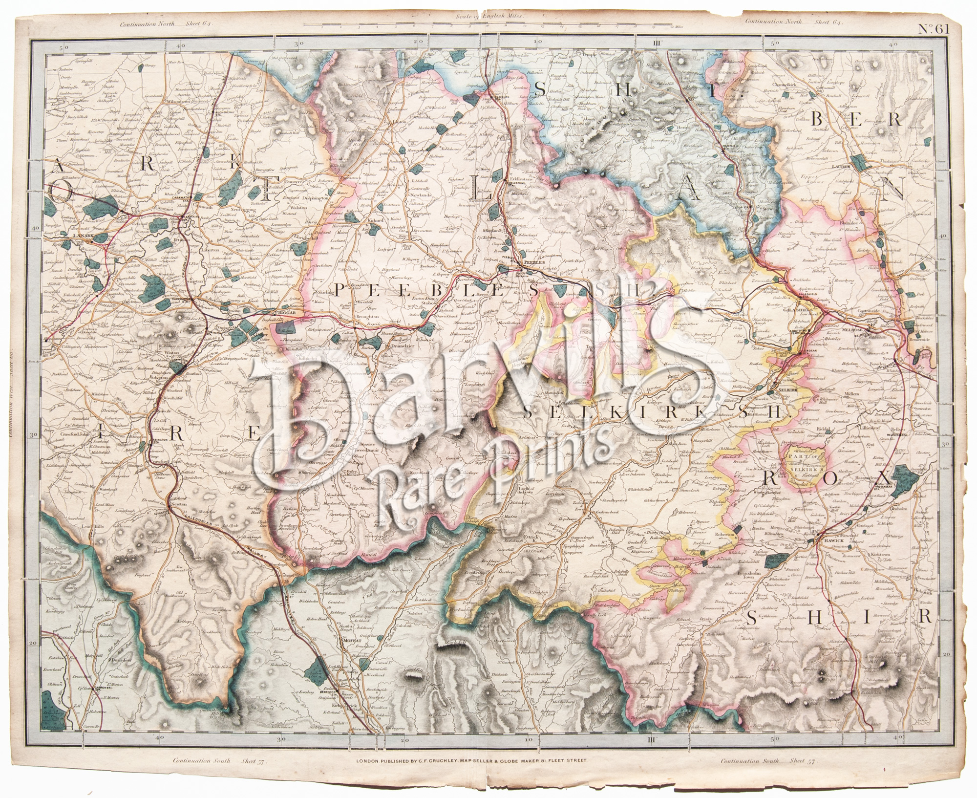 |
| Please click on above image for an enlarged view. The digital Darvill's watermark does not appear on the antique map. |
PLATE 61(The index map at the top of this page will help with locations) |
[part of Peebles, Selkirkshire, Roxburgh, Scotland] |
Cruchley's Complete Railway & Station Map of England and Wales with Part of Scotland Published by G. F. Cruchley, London |
Overall sheet size = approx. 26 x 21 inches (about 66 x 53 cm) Original 155+-year-old maps • hand-colored engraved maps, with center fold, as issued |
NOTE: ALL OF THE MAPS IN THIS SERIES HAVE NUMEROUS EDGE TEARS AND RAGGED TOP MARGINS. THERE IS ALSO AGE-APPROPRIATE TONING OF THE PAPER AND LIGHT FOXING. PLEASE ASSUME THIS TO BE TRUE OF EACH MAP OFFERED HERE. ANY OTHER MAJOR CONDITION ISSUES WILL BE NOTED BELOW.
|
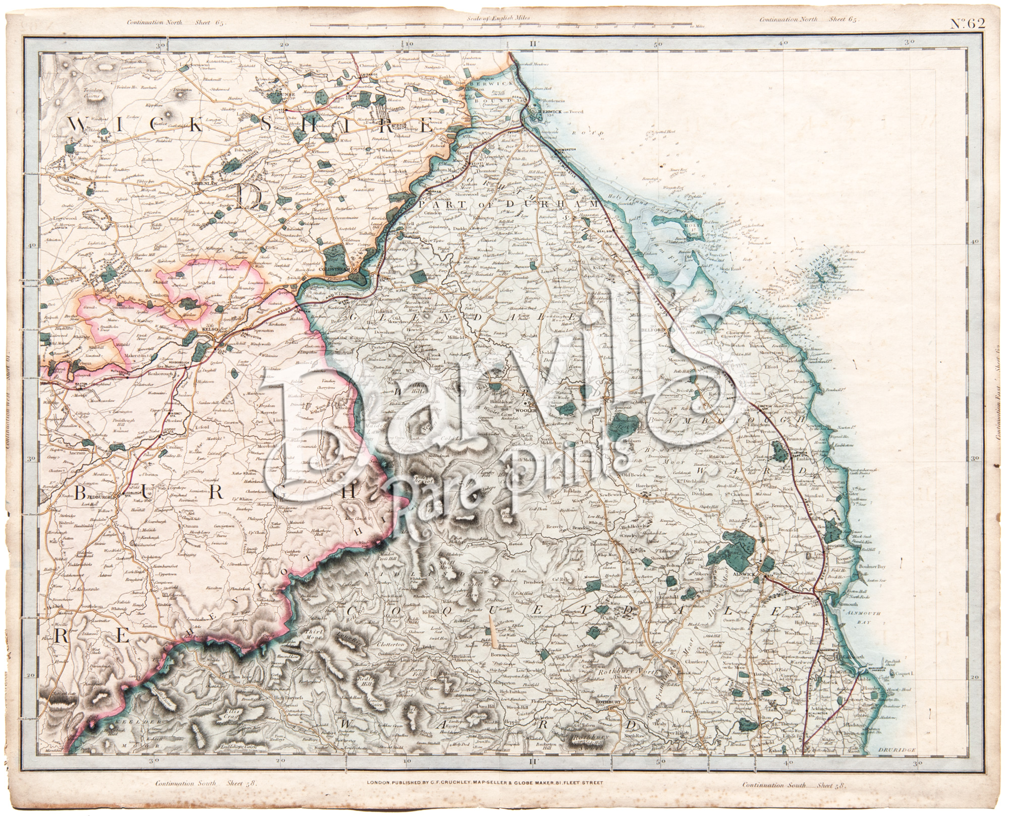 |
| Please click on above image for an enlarged view. The digital Darvill's watermark does not appear on the antique map. |
PLATE 62(The index map at the top of this page will help with locations) |
[part of Roxburgh, Derbyshire, Northumberland, Durham, Scotland] |
Cruchley's Complete Railway & Station Map of England and Wales with Part of Scotland Published by G. F. Cruchley, London |
Overall sheet size = approx. 26 x 21 inches (about 66 x 53 cm) Original 155+-year-old maps • hand-colored engraved maps, with center fold, as issued |
NOTE: ALL OF THE MAPS IN THIS SERIES HAVE NUMEROUS EDGE TEARS AND RAGGED TOP MARGINS. THERE IS ALSO AGE-APPROPRIATE TONING OF THE PAPER AND LIGHT FOXING. PLEASE ASSUME THIS TO BE TRUE OF EACH MAP OFFERED HERE. ANY OTHER MAJOR CONDITION ISSUES WILL BE NOTED BELOW.
|
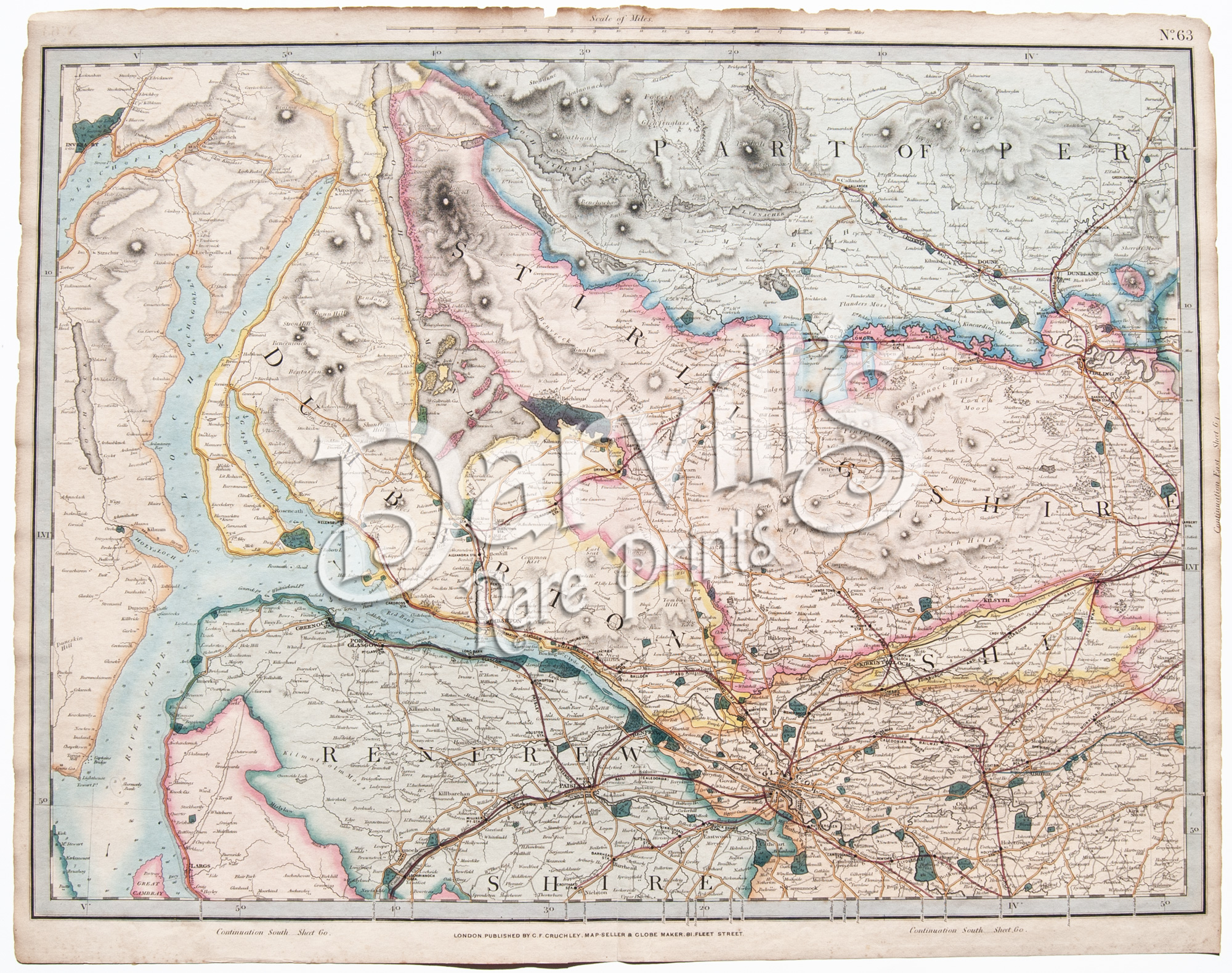 |
| Please click on above image for an enlarged view. The digital Darvill's watermark does not appear on the antique map. |
PLATE 63(The index map at the top of this page will help with locations) |
[part of Sterling Shire, Renfrew shire, Lanarkshire, Dumbartonshire, Glasgow, Scotland] |
Cruchley's Complete Railway & Station Map of England and Wales with Part of Scotland Published by G. F. Cruchley, London |
Overall sheet size = approx. 26 x 21 inches (about 66 x 53 cm) Original 155+-year-old maps • hand-colored engraved maps, with center fold, as issued |
NOTE: ALL OF THE MAPS IN THIS SERIES HAVE NUMEROUS EDGE TEARS AND RAGGED TOP MARGINS. THERE IS ALSO AGE-APPROPRIATE TONING OF THE PAPER AND LIGHT FOXING. PLEASE ASSUME THIS TO BE TRUE OF EACH MAP OFFERED HERE. ANY OTHER MAJOR CONDITION ISSUES WILL BE NOTED BELOW.
|
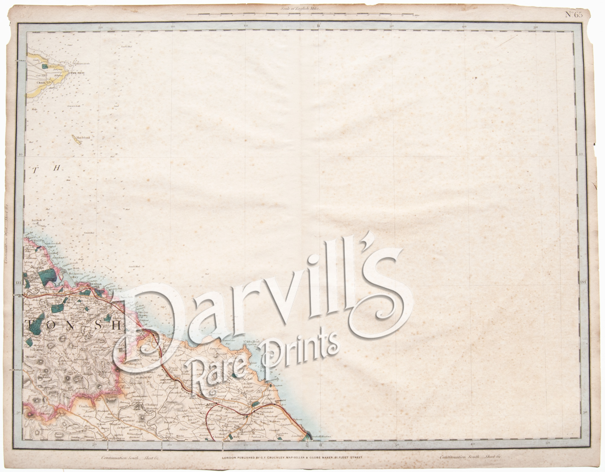 |
| Please click on above image for an enlarged view. The digital Darvill's watermark does not appear on the antique map. |
PLATE 65(The index map at the top of this page will help with locations) |
[part of Haddingtonshire, Berwickshire, Scotland] |
Cruchley's Complete Railway & Station Map of England and Wales with Part of Scotland Published by G. F. Cruchley, London |
Overall sheet size = approx. 26 x 21 inches (about 66 x 53 cm) Original 155+-year-old maps • hand-colored engraved maps, with center fold, as issued |
NOTE: ALL OF THE MAPS IN THIS SERIES HAVE NUMEROUS EDGE TEARS AND RAGGED TOP MARGINS. THERE IS ALSO AGE-APPROPRIATE TONING OF THE PAPER AND LIGHT FOXING. PLEASE ASSUME THIS TO BE TRUE OF EACH MAP OFFERED HERE. ANY OTHER MAJOR CONDITION ISSUES WILL BE NOTED BELOW.
|

(more maps from this series)
Thousands of original Vintage and Antique Maps and Sea Charts